La previsione dei fulmini in Italia

I fulmini rappresentano una reale minaccia per varie attività umane. Oltre a causare un numero di vittime tra 20 e 50 all’anno in Italia,  hanno un impatto sulle attività ricreative all’aperto, sull’aviazione, sulle industrie che si occupano a vario titolo di elettricità e su altri importanti settori.  Essi sono il risultato dello sviluppo di convezione intensa all’interno di una nuvola in presenza di ghiaccio e acqua liquida. L’intensificazione dei processi convettivi a causa del cambiamento climatico aumenterà le tempeste di fulmini a livello globale. Per queste ragioni è importante la loro previsione.

Uno studio frutto della collaborazione tra tra l’Istituto di scienze dell’atmosfera e del clima (Cnr-Isac), la Fondazione CIMA, la Protezione Civile, e l’Università di Gerusalemme, recentemente pubblicato sulla rivista Remote Sensing, mostra le prestazioni di un sistema modellistico per la previsione dei fulmini sull’Italia: il metodo unisce i campi dinamici e termidinamici di previsione di un modello meteorologico stato dell’arte con uno schema di elettrificazione delle nuovole messo a punto dall’Università di Geusalemme.

I risultati mostrano la fattibilità della previsione che ha una concreta affidabilità alle scale spaziali e temporali utilizzate dal sistema di allerta della Protezione Civile. Inoltre, i risultati mostrano una marcata dipendenza della previsione con le stagioni e con il tipo di superficie. In particolare, le prestazioni sono migliori in estate ed autunno e peggiori in inverno e primavera. Allo stesso modo, il sistema modellistico fornisce previsioni migliori sulla terra rispetto al mare. 

All’articolo è stata dedicata la copertina del volume 14 (2) della rivista (https://www.mdpi.com/2072-4292/14).


Riferimenti: https://www.cnr.it/it/news/11299

Per informazioni:
Stefano Federico:  s.federico@isac.cnr.it
06/49934209

Per fortuna c’è l’atmosfera!

E’ recentemente apparso sull’almanacco della scienza del CNR (qui)  un articolo divulgativo del collega Francesco Cairo.

L’articolo spiega in modo semplice ed intuitivo le cause dell’effetto serra dalle sue origini ai giorni nostri.

Fonte: Francesco Cairo, Istituto di scienze dell’atmosfera e del clima, e-mail: francesco.cairo@artov.isac.cnr.it


The Italian Tyrrhenian regions, a hotspot for Tornadoes in the Mediterranean

Extreme weather events such as tornadoes are increasingly documented in Italy. A recent research, carried out by the CNR-ISAC and published on Atmospheric Research, confirms that there are specific areas more affected by these phenomena; one of these is represented by the central Tyrrhenian regions of the Italian peninsula.

The work permitted to identify the prevalent synoptic configurations associated with tornadoes in the area, and to evaluate the predictive capabilities of such phenomena through the analysis of a case study.


Full text of the CNR press release here

Full text of the publication here


For information:

Elenio Avolio, Cnr-Isac Lamezia Terme

Viaggio tra le nuvole a Superquark

A Superquark, il programma di Piero Angela in onda su Rai 1, il 13 luglio scorso é andato in onda il servizio realizzato a Bologna presso l’Area Territoriale di Ricerca del CNR. Protagonista Vincenzo Levizzani (CNR-ISAC) che ha parlato dell’importanza dello studio delle nuvole e della pioggia, e degli strumenti attualmente utilizzati.

Il servizio è realizzato da Paolo Magliocco e Paola Toscano.

Per rivedere il servizio qui il link su RaiPlay

Atmospheric Rivers from Modeling and Remote Sensing

This Special Issue aims to improve the current knowledge of atmospheric rivers (ARs) through the publication of groundbreaking papers that focus on innovative and original approaches to that research. From first pioneering studies, the interest of the scientific community progressively grew, as demonstrated by several funded projects on this subject, many field and numerical experiments, and the large number of scientific publications. However, despite this improvement in the knowledge of ARs in terms of their dynamics, evolution, and impact on the precipitation rate, several scientific questions remain unexplored. An example is an evaluation of the effects of AR-forced rainfall on small–medium-sized hydrological basins.

Submitted articles may address, but are not limited to, the following scientific topics:

  • Impact of ARs on heavy rainfall, heavy snowfall and associated floods over the midlatitude areas.
  • Changes in the hydrological response of complex terrain due to Ars.
  • A special focus on the Mediterranean basin: the features, occurrence, seasonality, and effects of ARs in this complex domain.
  • AR-related storms in the contest of climate change.
  • ARs as a key operational product for nowcasting applications and flood risk management.


Guest Editors

Dr. Sante Laviola (CNR-ISAC), Dr. Francesco Chiaravalloti (CNR-IRPI), Dr. Annalina Lombardi (CETEMPS), Dr. Barbara Tomassetti (CETEMPS).

Deadline for manuscript submissions: 31 March 2023.

Further details can be found at the Special Issue web page


Da cosa dipende l’altezza delle dune del deserto?

Cosa regola l’altezza massima delle dune del deserto? Smettono mai di crescere e, in caso affermativo, quali sono i fattori che determinano le loro dimensioni finali? Partendo da un precedente risultato della fine degli anni 2000, hanno provato a rispondere a questa domanda alcuni ricercatori del Cnr-Isac (Giampietro Casasanta e Luca di Liberto) e Cnr-Ismar, in un lavoro internazionale con le Università di Monash, Stanford e della Pennsylvania, nonché con il Desert Research Institute, appena pubblicato sulla rivista Nature Communications.
Attraverso un’analisi globale della topografia, delle forzanti atmosferiche e dei vincoli geologici di un largo numero di dune giganti nei maggiori deserti di tutta la Terra, è stato possibile determinare come la crescita di queste strutture sia in linea di principio infinita, anche se dipende dalla loro morfologia, rallenta con l’aumentare delle dimensioni stesse e, in ultima istanza, può essere limitata dall’apporto di sabbia disponibile.

https://www.nature.com/articles/s41467-022-30031-1

In figura: Esempio di geometrie delle dune ed estrazione del flusso di sabbia

Caro Frank

It is with disbelief, dismay and deep sorrow that our institute learns the sad news of the untimely and sudden death of Prof. Frank Silvio Marzano, a friend and colleague of many at the institute.

Frank’s scientific calibre is undisputed and his studies will leave an important mark on the atmospheric science community. Many will also remember him for his empathy, his contagious smile and his professionalism. A friend to all, always and in any case, never against anything or anyone, Frank did not know the meaning of the word resentment. Constantly curious as children discover the world for the first time. A passionate educator. He loved to teach and he did it very well. His students adored him most of all because they recognised in him a healthy sense of balance in judging their performance. Frank was also an amazing team builder. For more than 10 years he organised an annual games day on the beach to which he invited people who worked with him, and on the terrace of the Engineering Department where he taught, he was one of the first to organise refreshments before the summer holidays. Holidays that he continued to devote to cultivating new ideas, writing assignments and projects. He was always in a rush. Busy with a thousand activities, it was difficult to keep up with him. He took transport literally on the fly because he had no time to waste, the days were always too short for him.

Frank was always aiming high, and now that he’s reached the top, we’re sure that even there he won’t be idle, he’ll continue to observe the clouds from up there, riding his waves (EM), with his unmistakable style.

Goodbye Frank, you leave a great void in all of us.

To his beloved children Marianna and Lorenzo, and to his beloved wife Antonella, go the heartfelt condolences of the entire institute.


Il Prof. F.S. Marzano è professore ordinario (settore ING-INF/02, Campi elettromagnetici) presso la Sapienza Università di Roma (Roma, IT). Ha ricevuto la Laurea cum laude in Ingegneria Elettronica (1988) e il Dottorato di Ricerca (1993) in Elettromagnetismo Applicato e Scienze Elettrofisiche dall’Università di Roma “La Sapienza”. Nel 1992 è stato ricercatore in visita alla Florida State University, Tallahassee, FL. Durante il 1993 ha collaborato con l’Istituto di Fisica dell’Atmosfera, Consiglio Nazionale delle Ricerche (CNR), Roma. Dal 1994 al 1996, è stato ricercatore di post-dottorato con l’Agenzia Spaziale Italiana, Roma. Dopo essere stato professore a contratto presso l’Università di Perugia, nel 1997 ha preso servizio presso il Dipartimento di Ingegneria Elettrica dell’Università dell’Aquila, insegnando corsi di campi elettromagnetici. Nel 1999 è stato ricercatore in visita presso il Naval Research Laboratory (NRL), Monterey, CA. Nel 2002 ha ottenuto l’idoneità a Professore Associato ed ha co-fondato il Centro di Eccellenza in Telerilevamento E Modellistica Previsionale di eventi Severi (CETEMPS) dell’Università dell’Aquila, diventandone il coordinatore del laboratorio di Telerilevamento radar e satellitare e il vice-direttore dal 2007. Nel 2005 e nel 2019 ha preso servizio, come professore associato e ordinario rispettivamente, presso il Dipartimento di Ingegneria Elettronica dell’Università di Roma “La Sapienza”, attualmente Dipartimento di Ingegneria dell’Informazione, Elettronica e Telecomunicazioni (DIET). Dal 2013 ad oggi è direttore del Centro di Eccellenza CETEMPS presso L’Aquila.

  • Didattica. Il Prof. Marzano attualmente insegna corsi su campi elettromagnetici, radar meteorologia, antenne, propagazione e osservazione della Terra nell’ambito della laurea e laurea magistrale in Ingegneria Elettronica, del Master degree in Data Science e in Atmospheric Science and Technology presso Sapienza. È stato presidente dal 2013 al 2019 dell’Area didattica di Ingegneria Elettronica della Sapienza, che conta più d i 600 studenti iscritti, essendone dal 2020 vice-Presidente. È stato promotore dell’istituzione nel 2018 della Laurea magistrale interateneo internazionale in Atmospheric Science and Technology (LMAST), di cui è vice-presidente dal 2019. Il prof. Marzano ha insegnato presso l’Università dell’Aquila, di Perugia e di Roma “La Sapienza” ed, dal 1997, è stato relatore di laurea di più di 200 studenti di laurea triennale, più di 75 studenti di laurea specialistica e magistrale e di 20 studenti di dottorato di ricerca. È stato membro del Dottorato di ricerca in Ingegneria elettrica e dell’informazione dell’Università dell’Aquila dal 1997 al 2001, del Dottorato in Metodi e tecniche di monitoraggio ambientale dell’Università della Basilicata dal 2001 al 2006, del Dottorato in Ingegneria Elettronica e Telerilevamento dell’Università di Roma “La Sapienza” dal 2007 al 2012 e, dal 2013, del Dottorato in Tecnologia della Comunicazione e Informazione (ICT). Nel 2000 è stato il co-fondatore e direttore della prima edizione della International Summer School on Atmospheric and Oceanic Sciences (ISSAOS), svoltasi a L’Aquila, arrivato nel 2011 alla sua tredicesima edizione nel 2016. Il Dr. Marzano è stato relatore invitato su temi di telerilevamento e radio propagazione in diverse conferenze e scuole internazionali.
  • Ricerca. La ricerca scientifica del prof. Marzano riguarda metodi di ottimizzazione, apprendimento e predizione numerica di sistemi non-lineari, telerilevamento passivo e attivo dell’atmosfera da terra, da aereo e da satellite con un particolare interesse su nubi e precipitazione mediante l’uso di dati a microonde e infrarosso, sviluppo di metodi inversi basati su modelli fisico-matematici, modellistica di trasferimento radiativo attraverso mezzi attenuativi e diffondenti, meteorologia radar per la stima di pioggia e vento ed elaborazione di dati di radar ad apertura sintetica per applicazioni di uso del suolo. E’ anche coinvolto in studi di radiopropagazione e ottica di spazio libero, includenti scintillazione di campi elettromagnetici, modellistica di attenuazione da pioggia e analisi di dati di collegamenti via satellite a microonde e a onda millimetrica per applicazioni di comunicazioni e missioni interplanetarie di spazio profondo. Recentemente si è anche occupato di osservazioni remote di nubi eruttive vulcaniche da sensori radar e radiometrici dal punto di vista sia modellistico che sperimentale. Oltre all’abilitazione ANVUR al ruolo di professore ordinario nel settore ING-INF/02 (Campi elettromagnetici) nel 2103, il Prof.Marzano ha conseguito l’abilitazione al ruolo di professore ordinario anche in FIS/06 nel 2013 e in GEO/12 nel 2018. L’indice bibliometrico H-index della sua produzione scientifica, aggiornato al 2020, è pari a 30 da fonte SCOPUS e a 41 da fonte Google Scholar.
  • Pubblicazioni. Il prof. Marzano ha pubblicato più di 150 articoli su riviste internazionali, più di 30 contributi su capitoli di libri internazionali e più di 300 sommari estesi su atti di congressi internazionali e nazionali. È stato co-editore del libro “Remote sensing of atmosphere and ocean from space: models, instruments and techniques”, Kluwer Acad. Plub., Dordrecht (NL), 2002 e “Integrated Ground-Based Observing Systems Applications: for Climate, Meteorology, and Civil Protection”, Springer , Berlin (D). È revisore delle maggiori riviste internazionali di telerilevamento, radiometeorologia e radiopropagazione. Dal gennaio 2004 fino a gennaio 2012 è stato Editore Associato della rivista IEEE Geoscience Remote Sensing Letters, mentre nel 2005 è stato Co- Editore ospite del numero speciale MicroRad04 e MicroRad06 della rivista IEEE Transactions on Geoscience and Remote Sensing. Dal 2011 è Editore Associato della rivista Copernicus Atmospheric Measurement Techniques (AMT) e dal 2012 è Editore Associato della rivista IEEE Transactions on Geoscience and Remote Sensing. E’ co-autore del libro di testo universitario “Fondamenti di Antenne”, Carocci (Roma, I), pubblicato nel 2011, adottato nelle principali università italiane con corsi nell’ambito dell’ingegneria dell’informazione.
  • Progetti. Dal 1991 il prof. Marzano ha partecipato a numerosi progetti di ricerca internazionali (e.g., GPCP-AIP- 2, GPCP-AIP3, NASA-PIP2, NASA-PIP3, EU-COST-712, EU-COST-255), progetto finanziati dall’Unione Europea (e.g., STORM nel 3th EU-FP, MEFFE nel 3th EU-FP, EuroTRMM nel 4th EU-FP, EuRAINSAT nel 5th EU-FP, RiskAWARE nel INTERREG III-B CADSES, HYDRORAD nel FP7, HYDREX nel FP7, ADRIARadNet e CapRadNet in IPA e AdriaMORE in IT-HR), e studi finanziati dall’ESA legati a missioni satellitari e applicazioni meteorologiche (e.g., DMSP, TRMM, ENVISAT, MSG, MetaWave, Wband, RadioMetOP, WRad, MeKaP). È stato coinvolto nel gruppo di calibrazione del satellite ENVISAT, il gruppo scientifico per lo studio di fattibilità delle missioni I-GPM e E-GPM e co-investigatore nell’ambito di progetti dell’Agenzia Spaziale Italiana (ASI), del Consiglio Nazionale dell Ricerche (CNR) e di EUMETSAT. Nel 2009 ha coordinato lo studio della piccola missione spaziale FloRad per conto dell’ASI, dal 2012-2015 ha coordinato europeo del progetto europeo IPA ADRIARadNet e nel 2016 del progetto IPA CapRadNet. Dal 2001 al 2006 il prof. Marzano è stato delegato nazionale italiano per le azioni quinquennali europee COST n. 720 su “Integrated ground-based remote sensing stations for Atmospheric profiling” e n. 280 su “Propagation impairment mitigation for millimeter wave radio systems”. Nel 2002 ha contribuito alla pianificazione e progetto della nuova rete radar meteorologica all’interno di un progetto del Dipartimento italiano di Protezione Civile. Dal 2008 al 2012 è stato delegato italiano del progetto europeo COST Action project ES702 “EGCliMet” e COST Action project IC0802 “PropTNEO”. Dal 2010 è membro del comitato internazionale European Volcanic Ash Cloud Expert Group (EVACEG) e dal 2011 è vice-delegato nazionale del progetto europeo COST Action project IC1101 “OpticWISE” e coordinatore del gruppo di lavoro sui modelli fisici. Nel 2009 è diventato membro del Science team of the Global Precipitation Mission (GPM) e nel 2012 è stato nominato membro del comitato EuMetSat Precipitation Science Advisory Group e MWI-ICI Science Advisory Group (SAG). È stato ed è consulente di industrie nazionali di ingegneria e agenzie internazionali, coinvolte nell’ingegneria a microonde e in sistemi di telerilevamento.
  • Titoli. Il prof. Marzano ha ricevuto nel 1990 un premio di studio dall’Elettronica S.p.A. (Roma, I) per ricerche su radiometria a microonde. Nel 1993 ha ricevuto il premio Young Scientist Award of XXIV General Assembly dell’International Union of Radio Science (URSI). Nel 1998 è stato insignito del premio Alan Berman Publication Award (ARPAD) da parte del the Naval Research Laboratory, Washington, DC. Nel 2008 e 2011 ha ricevuto il premio Best Paper Award dalla EGU-Plinius Conferences a Nicosia (Cyprus) e Savona (Italy), rispettivamente, mentre nel 2009 ha ricevuto il premio “Best Oral Paper Award on propagation” dalla EuCAP Conference (Berlin, Germany). Nel 2012 il prof. Marzano è stato insignito del titolo di Fellow of the Royal Meteorological Society (RMetS) e nel 2015 del prestigioso titolo di Fellow dell’Institute of Electrical and Electronic Engineers (IEEE) per “contributions to microwave remote sensing in meteorology and volcanology”. È membro della Società Italiana di Elettromagnetismo (SIEm), nonchè socio della American Meteorological Society (AMS). Dal 2005 al 2017 il Prof. Marzano è stato vice-presidente del IEEE-GRS Chapter n. 21 of Central-North Italy, di cui è presidente dal 2018. È anche membro di Amnesty International (Rome, Italy), World Wild Fund (Rome, Italy), e “Save The Children” Association (Rome, Italy).

Precipitation monthly and daily gridded data (2000-2017) from PWM observations

The new gridded dataset of precipitation provides global estimates of daily accumulated and monthly means of precipitation at 1° spatial resolution from 2000 to 2017. The precipitation estimates are based on merged passive microwave observations from conically-scanning imagers and cross-track scanning sounders operating on multiple Low Earth Orbit satellites.

This dataset has been produced with funding from the Copernicus Climate Change Service (C3S) which is implemented by ECMWF on behalf of the European Commission from a collaboration between DWD and CNR-ISAC under the C3S_312b_Lot1 contract.

More details can be found at the catalogue page of the C3S Climate Data Store: 

https://cds.climate.copernicus.eu/cdsapp#!/dataset/satellite-precipitation-microwave?tab=overview


Konrad, Hannes; Panegrossi, Giulia; Bagaglini, Leonardo; Sanò, Paolo; Sikorski, Thomas; Cattani, Elsa; Schröder, Marc; Mikalsen, Anna-Christina; and Hollmann, Rainer (2022): Precipitation monthly and daily gridded data from 2000 to 2017 derived from satellite microwave observations Copernicus Climate Change Service (C3S). Climate Data Store (CDS). https://doi.org/10.24381/cds.ada9c583

Special Issue “Indoor air quality: monitoring, modeling, challenges and new perspective”

Special Issue Announcement:

Indoor air quality: monitoring, modeling, challenges and new perspective” of the journal Atmosphere (ISSN 2073-4433), belongs to the section “Air Quality”.
The topics of interest for this Special Issue include, but are not limited to the following:

  • Aerosols
  • COVID-19
  • Cultural heritage
  • Dispersion
  • Exposure
  • Gases
  • Health
  • Indoor air quality
  • Microbiological assessment
  • Modeling

Deadline for manuscript submissions: 24 June 2022.

Guest Editors

Dr. Ana Isabel Calvo Gordaliza
Dr. Carlos Blanco-Alegre
Dr. Paola De Nuntiis

Detailed information about the Special Issue can be found here:
https://www.mdpi.com/journal/atmosphere/special_issues/indoor_air_quality_new_perspective

Passa ad ISAC il coordinamento della rete internazionale SKYNET

SKYNET (https://www.skynet-isdc.org) è una rete di fotometri, strumenti che, attraverso la misura della radiazione solare, stimano le caratteristiche del particolato atmosferico e la quantità del vapor d’acqua lungo l’intera colonna d’aria, fornendo informazioni essenziali tanto per gli studi climatici quanto per le valutazioni della qualità dell’aria. La rete consta di oltre 100 strumenti disseminati in tutto il globo, Antartide incluso, che operano in maniera automatica e continua fornendo dati verificati in tempo reale, scaricabili e accessibili liberamente.

Per la prima volta, attraverso l’Istituto di Scienze dell’Atmosfera e del Clima del Consiglio Nazionale delle Ricerche (CNR-ISAC), la comunità scientifica italiana che si occupa di studi sulla radiazione solare a scopi atmosferici e climatici assume un ruolo di primo piano nel contesto internazionale. L’ultima riunione del comitato scientifico della rete SKYNET ha infatti assegnato alla dott.ssa Monica Campanelli di CNR-ISAC il coordinamento internazionale delle sue attività.

I dati della rete SKYNET hanno permesso di studiare negli anni, a livello europeo e nazionale, numerosi eventi importanti sia per l’impatto antropico che per lo studio dei cambiamenti climatici e di pubblicarne i risultati su riviste internazionali. Ad esempio è stato possibile individuare il trasporto della polvere emessa dal vulcano Eyjafjallajökull nel 2010 lungo il suo percorso dall’Islanda fino all’Italia, passando per il Nord Europa, discriminando i giorni di trasporto di particelle fini, generate dalla condensazione dei gas emessi, da quelli di trasporto di ceneri che hanno proprietà radiative differenti. Misure nel sito di Aosta nel 2019, in sinergia con altra strumentazione, hanno permesso di dimostrare che le regioni montuose, spesso considerate ambienti incontaminati, possano risentire degli inquinanti emessi nelle aree più popolate e industrializzate, come il bacino del Po, e che, trasportati dai venti regionali, portano ad un aumento dei PM. In ultimo, uno studio sugli effetti del lockdown (nel 2020) sulle atmosfere urbane di alcuni siti nel territorio nazionale si è avvalso anche di strumentazione SKYNET per studiare l’influenza delle condizioni meteorologiche sulla concentrazione dei PM, permettendo il riconoscimento di eventi di trasporto a lungo raggio, quali ad esempio il fumo proveniente dagli incendi dall’Europa orientale e dal Montenegro, le polveri dall’area del Caspio e dal Sahara, gli inquinanti dalla Pianura Padana verso Aosta.

Per informazioni: Monica Campanelli, Cnr-Isac, m.campanelli@isac.cnr.it,  

Intervista a Marcello Miglietta su Rainews24 sui recenti tornado negli Stati Uniti

Il recente e devastante “outbreak” di tornado che ha interessato gli Stati Uniti solleva la questione di quanto i cambiamenti climatici influiscano su questi fenomeni. Nell’intervista viene spiegato che l’attribuzione di questi fenomeni al cambiamento climatico non è facile da determinare. Comunque, i dati disponibili negli USA degli ultimi 60 anni indicano un aumento significativo delle situazioni estreme in cui più tornado violenti si verificano simultaneamente.

Il video dell’intervista è disponibile a questo link

RICERCATORI INFLUENTI – 2021

La rivista PLOS Biology ha pubblicato il ranking del 2% di ricercatori più influenti al mondo nel proprio campo di ricerca secondo metriche basate sulle citazioni ricevute da altri autori (https://doi.org/10.17632/btchxktzyw.3).

Alcuni ricercatori ISAC sono presenti nelle diverse categorie:
– nella graduatoria “carriera” figurano – Maria Cristina Facchini – Dario Camuffo (ora associato) – Sandro Fuzzi (ora associato) – Guido Boffetta (associato)
– nella graduatoria “anno 2020” figurano – Francesca Cigna – Daniele Contini – Francesco Marra – Dario Camuffo (ora associato) – Sandro Fuzzi (ora associato) – Guido Boffetta (associato) – Mauro La Russa (associato)

Dati e liste si possono scaricare dalla repository aggiornata: Baas, Jeroen; Boyack, Kevin; Ioannidis, John P.A. (2021), “August 2021 data-update for “Updated science-wide author databases of standardized citation indicators””, Mendeley Data, V3, https://doi.org/10.17632/btchxktzyw.3
Dettagli sulle tecniche usate per armonizzare le diverse aree scientifiche si trovano nell’articolo originale: Baas & al., 2019, https://doi.org/10.1371/journal.pbio.3000384

Susanna Corti a TG Leonardo

Susanna corti, uno dei cinque autori italiano del sesto rapporto dell’IPCC, spiega a TG Leonardo quali sono le evidenze del cambiamento climatico e chiarisce da quale situazione partiamo e quali sono i limiti che dobbiamo imporre alle nostre emissioni di anidride carbonica per restare al di sotto di un innalzamento della temperatura di 1.5°C o di 2°C di rispetto all’era pre-industriale.

Intervista a Susanna Corti nel Tg Leonardo del 1/11/2021 (dal minuto 3:58): https://www.raiplay.it/video/2021/11/TGR-Leonardo-del-01112021-942f1066-8448-49cd-b545-1434f5f55de7.html

Speciale TG1 – Direttrice ISAC per commentare il G20

Speciale TG1 del 30 ottobre 2021 RAI 1  – “Arrivo al Vertice dei Capi di Stato e di Governo dei Paesi appartenenti al G20 e dei Ministri dell’Economia”

Maria Cristina Facchini,  Direttrice CNR-ISAC, invitata in studio per commentare le questioni scientifiche relative ai cambiamenti climatici.
Tra gli esperti anche Valeria Termini, Professore ordinario di Economia politica all’Università Roma Tre e Consigliere Scientifico dell’Istituto Affari Internazionali (IAI), per discutere i risvolti economici dell’emergenza pandemica e Paolo Magri, Vice Presidente Esecutivo e Direttore dell’Istituto per gli Studi di Politica Internazionale (ISPI), per analizzare gli aspetti geopolitici del G20. 

Disponibile su RaiPlay: https://www.raiplay.it/video/2021/10/Tg1-ore-0955-del-30102021-1c0dc963-b258-44d0-8b02-38f6e1ea7806.html

Un ciclone Mediterraneo a sud della Sicilia

In queste brevi interviste il Dr Mario Marcello Miglietta illustra la situazione meteorologica che ha determinato le forti precipitazioni a sud della Sicilia, e evidenzia la possibile evoluzione del ciclone responsabile dell’evento in “uragano Mediterraneo”. Nell’ambito dei cambiamenti climatici, tali eventi sono destinati ad intensificarsi per la presenza di un mare più caldo e quindi un maggiore trasferimento di energia in atmosfera. Inoltre vengono spiegati i meccanismi che caratterizzano un medicane e lo distinguono da un ciclone extra-tropicale.

Nel servizio del TG Leonardo del 27/10 il Dr Silvio Davolio chiarisce il legame tra le forti precipitazioni avvenute in Sicilia e la possibiltà di intensificazione del ciclone Mediterraneo.

Al TG1 il Dr Silvio Davolio ci parla della possibile traiettoria e degli effetti attesi.

Intervista a Mario Marcello Miglietta nel Tg3 ore 19:00 del 26/10/2021 (dal minuto 04:30): https://www.raiplay.it/video/2021/10/Tg3-ore-1900-del-26102021-d3a6fa9c-636b-4946-bfc6-c016e515cb56.html

Intervista a Mario Marcello Miglietta nel Tg1 ore 20:00 del 27/10/2021 (dal minuto 23:07): https://www.raiplay.it/video/2021/10/Tg1-ore-2000-del-27102021-8faf7a36-94b1-40f2-93f4-eb8fbe45f44d.html

Intervista a Silvio Davolio nel Tg Leonardo del 27/10/2021 (dal minuto 4:13): https://www.rainews.it/tgr/rubriche/leonardo/index.html?/tgr/video/2021/10/ContentItem-4069a1e0-614a-4072-ab14-878668ae78e2.html

Intervista a Silvio Davolio nel Tg1 ore 20:00 del 27/10/2021 (dal minuto 29:25): https://www.raiplay.it/video/2021/10/Tg1-ore-2000-del-28102021-b65f83d9-5209-437a-837a-43e515901bcd.html

Contagio in aria indoor: quasi azzerato dalle norme

Mensa, parrucchiere, centri commerciali. Venezia-Mestre, Bologna, Lecce. Con mascherina, distanziamento e ricambio d’aria, nei luoghi pubblici al chiuso il rischio di trasmissione in aria del Sars-Cov-2 è risultato inferiore al minimo rilevabile. Lo evidenzia uno studio condotto per la prima volta in Italia, dagli Istituti di Scienze dell’atmosfera e del clima e di Scienze polari del Cnr, Università Ca’ Foscari Venezia e Istituto Zooprofilattico sperimentale della Puglia e della Basilicata, pubblicato su Environmental Science and Pollution Research.

Per maggiori informazioni consultare qui

Per la pubblicazione integrale qui

Per informazioni: 

Daniele Contini, Cnr-Isac sede di Lecce

Andrea Gambaro, Università Ca’ Foscari Venezia

Giovanna La Salandra, Izspb – sede centrale di Foggia


Gli effetti del lockdown nelle atmosfere urbane

Con il lockdown più bassi i livelli di particolato, biossido di azoto e benzene. Lo rivela uno studio pubblicato su Urban Climate condotto dell’Istituto di scienze dell’atmosfera e del clima del Cnr, in collaborazione con Università Sapienza, Enea, Cnr-Iia, Arpa Lazio e Val D’Aosta, Serco e ARIA-Net.

Per approfondimenti qui

Contatti

Monica Campanelli, Stefania Argentini
Cnr-Isac
m.campanelli@isac.cnr.it
s.argentini@isac.cnr.it

Uno sguardo all’interno di una supercella mediterranea per mezzo di radar meteorologici

Per la prima volta in Italia, un gruppo di ricerca, che ha visto la collaborazione trasversale tra enti di ricerca (CNR-ISAC Istituto di Scienze dell’Atmosfera e del Clima), enti operativi (DPC, Dipartimento Nazionale della Protezione Civile) ed enti universitari (CETEMPS Università degli studi dell’Aquila e DIET Sapienza Università di Roma), è riuscito a documentare con dovizia di particolari la dinamica e la morfologia di una supercella mediterranea (temporale molto intenso e potenzialmente dannoso) utilizzando le misure di due radar meteorologici del DPC.

Testo integrale della news reperibile qui

Testo integrale del lavoro scientifico reperibile qui  (accesso libero fino al 13 Novembre 2021)

Scuola Internazionale SORBETTO2 e Campagna di intercalibrazione QUATRAM3

Nel mese di Settembre ISAC ha organizzato due grandi eventi.

La scuola Internazionale SORBETTO 2 (SOlar Radiation Based Established Techniques for aTmospheric Observations) si è tenuta ONLINE, dal 13 al 15 Settembre 2021, ed ha visto la partecipazione di più di 100 studenti da 49 Nazioni. La scuola, organizzata in collaborazione con L’Università di Roma Sapienza, e finanziata da SERCO e dal progetto Europeo EMPIR-MAPP (Metrology for Aerosol oPtical Properties) si è avvalsa dell’esperienza di 20 insegnanti di fama internazionale provenienti da rinomati Università e Centri di Ricerca.

In foto il gruppo degli insegnanti.


Simultaneamente, dal 6 al 20 Settembre, ISAC ha organizzato la campagna internazionale di intercalibrazione QUATRAM3 finanziata sempre dal progetto Europeo EMPIR-MAPP. 8 strumenti, fra fotometri e spettrometri sono stati installati nell’aerea urbana di Roma, nel supersito di BAQUNIN presso il Dipartimento di Fisica della Sapienza, ed hanno operato simultaneamente per 3 settimane.

Qui sotto una spettacolare foto degli strumenti all’alba.

SORBETTO2 International school & QUATRAM3 Intercalibration campaign

During  September ISAC organized two major events.

The International school SORBETTO 2 (SOlar Radiation Based Established Techniques for aTmospheric Observations) was held ONLINE, from 13 to 15 September 2021, and saw the participation of more than 100 students from 49 countries. The school, organized in collaboration with the University of Rome Sapienza, and funded by SERCO and the European project EMPIR-MAPP (Metrology for Aerosol oPtical Properties), took advantage of the experience of 20 internationally renowned teachers from renowned universities and Research Centers.

In the image a picture of the group of teachers.

Simultaneously, from 6 to 20 September, ISAC organized the International QUATRAM3 intercalibration campaign funded by the European project EMPIR-MAPP. 8 instruments, including photometers and spectrometers, were installed in the urban area of ​​Rome, in the BAQUNIN supersite at the Physics Department of Sapienza, and operated simultaneously for 3 weeks.

Below a spectacular photo of the instruments at dawn.

Notte Europea dei Ricercatori – 24 Settembre 2021

Siamo tornati! Per andare incontro a tutte le esigenze quest’anno ci siamo sdoppiati, proponendovi eventi sia online che in presenza presso le città sedi del nostro Istituto, nell’ambito dei Progetti finanziati dalla Commissione Europea e iniziative locali.
Di seguito le attività in programma per la Notte del 24 settembre 2021.

L’accesso in presenza in molte sedi sarà consentito solo esibendo green pass valido ad esclusione dei minori di 12 anni.

ISAC Bologna society
Progetto SOCIETY RINASCIMENTO http://nottedeiricercatori-society.eu/
Oltre al coinvolgimento diretto nell’organizzazione di tutti gli eventi della notte e dei pre-notte (APERISCIENZA e LA RICERCA VA IN CITTÀ (E DINTORNI) ISAC sarà a Bologna. Scarica qui i programmi dal VIVO e ONLINE 

Postazione con esperimenti 
Meteorologia e Clima, che fenomeni! (Silvio Davolio, Marco Paglione, Angela Marinoni)

ISAC Lecceern-apulia
Progetto ERNApulia3 https://www.ern-apulia.it/

Seminari
 Medicanes, gli uragani del Mediterraneo (Mario Marcello Miglietta) https://www.ern-apulia.it/evento/medicanes-gli-uragani-del-mediterraneo/

Poster
X Med-Dry –  Deposizioni secche a Lecce: composizione e regioni di sorgenti potenziali. (Pierina Ielpo, Konrad Kandler, Cirillo Luca Ciricugno, Ferdinando De Tomasi) https://www.ern-apulia.it/evento/x-med-dry-deposizioni-secche-a-lecce-composizione-e-regioni-di-sorgenti-potenziali/

Valutazione della qualità dell’aria in una scuola secondaria di Galatina LE (Pierina Ielpo, Cristina Mangia, Gianluigi de Gennaro, Alessia Di Gilio, Iolanda Palmisani, Adelaide Dinoi, Andrea Bergomi, Valeria Comite, Paola Fermo) https://www.ern-apulia.it/evento/valutazione-della-qualita-dellaria-in-una-scuola-secondaria-di-galatina-lecce/

Video
Le attività di ricerca in Artico del centro ENI-CNR di Lecce (Federico Scoto, Gianluca Pappaccogli, Mauro Morichetti, Pierina Ielpo, Antonio Donateo, Umberto Rizza) https://www.ern-apulia.it/video/isac-ndr-2020-svalbard/ https://www.ern-apulia.it/evento/le-attivita-di-ricerca-in-artico-del-centro-eni-cnr-di-lecce/

Quale ricerca al confine tra scienza e politica nei contesti ambiente e salute? (Cristina Mangia) https://eee.ern-apulia.it/evento/quale-ricerca-al-confine-tra-scienza-e-politica-nei-contesti-ambiente-e-salute/

Medicina di genere. Caccia alle differenze (Cristina Mangia) https://www.ern-apulia.it/evento/medicina-di-genere-caccia-alle-differenze/

Volcanic Plume Transport from Etna (Umberto Rizza)  video animato – evento on line

ISAC Lamezia Terme  Super Science
Progetto SuperScienceMe: REsearch is your R-Evolution https://www.superscienceme.it/

Video
(Avolio Elenio, Ivano Ammoscato, Claudia Calidonna, Mariafrancesca De Pino, Daniel Gulli, Lo Feudo Teresa)

Le fonti di energia rinnovabile non programmabili: fotovoltaico ed eolico. Come esse rientrano tra le misure attuabili per rispondere al fabbisogno energetico e la loro utilità per la mitigazione dei cambiamenti climatici nel Green Deal.

Aerosol e suoi impatti sul clima. Descrizione dei principali impatti e degli strumenti che permettono la misura delle proprietà chimico-fisiche ed ottiche degli aerosol in atmosfera presso l’Osservatorio Climatico Ambientale GAW di Lamezia Terme

Strumentazione e misure di variabili meteorologiche. Si illustreranno le variabili meteo-climatiche misurate in tempo reale e saranno illustrati gli impatti sul clima, anche mediante prodotti modellistici.

ISAC Padova padova
Iniziativa VenetoNightPadova https://venetonightpadova.it

Seminario
Nuovi sistemi energetici per la sostenibilità degli edifici con dimostrazione live di uno strumento sviluppato in neoclass+, che serve per la valutazione del comfort termoigrometrico degli edifici produttivi (Gianluca Cadelano)

ISAC Torino sharper
Progetto SHARPER https://www.sharper-night.it/

Terrazza Caffe
Cambiamenti Climatici: insolite prospettive di osservazione (Enrico Ferrero, Katinka Bellomo Repetto, Jost Von Hardenberg)

Nota Stampa CNR https://www.cnr.it/it/nota-stampa/n-10579/il-cnr-tra-i-protagonisti-della-notte-europea-dei-ricercatori


CNR-ISAC is ready to host external users at the Mt. Cimone – Po Valley facility (ATMO-ACCESS)

The CNR-ISAC ATMO-ACCESS website has been activated. The purpose of the website is to provide information to foreign users who want to access the Mt. Cimone – Po Valley facility as part of the H2020 ATMO-ACCESS project. ATMO-ACCESS will deliver a series of recommendations for establishing a comprehensive and sustainable framework for access to distributed atmospheric Research Infrastructures (RI), ensuring integrated access to and optimized use of the services they provide. ATMO-ACCESS mobilizes extensive resources in the atmospheric RIs communities to engage into harmonizing access procedures in relation to policies, financial regulations and conditions for access.

As part of the Trans-National Access (TNA) activities in ATMO-ACCESS, CNR-ISAC provides the possibility to access research, technical and data supply services related to ground-based atmospheric observations at the three platforms composing the CMN-PV facility: the “O. Vittori “observatory at Monte Cimone, the CNR-ISAC OpenLab in Bologna and the atmospheric observatory at S. Pietro Capofiume.

Taking into consideration the restrictions related to the containment of the spread of COVID-19, for foreign users who will participate in the TNA program, it will be possible to access both by “traditional” physical and/or “smart” remote mode, the latter thanks to the constant support of the CNR-ISAC Technical Department.

The first call to participate in the ATMO-ACCESS TNA program is scheduled for October 2021.

More information on https://atmo-access.isac.cnr.it/ and on the general site of ATMO-ACCESS https://www.atmo-access.eu/

For contacts at CNR-ISAC: atmo-access@isac.cnr.it

Safeguarding cultural heritage from climate change related hydrometeorological hazards

An article published in the International Journal of Disaster Risk Reduction presents an innovative method to help assess the risk of cultural heritage exposed to extreme hydrometeorological events related to climate change. The system was designed and developed as part of two Interreg Central Europe Projects coordinated by the ICNR-ISAC of Bologna – ProteCHt2save and Strench. In order to improve the resilience to calamitous events, the preparation is the decisive action in the management of cultural heritage sites and the tool realized supports concretely the operators of the public and private sector

Cultural heritage is increasingly exposed to the disastrous effects of extreme events linked to climate change such as floods and heavy rains. Unfortunately, despite being of great importance, not only for its cultural value, but also for related socio-economic aspects, this sector is still not exhaustively considered in the Strategies for Disaster Risk Reduction (Sendai Framework) and the National Climate Change Adaptation Plans (Pnacc).

Recently, the researchers of the CNR-ISAC in Bologna, are engaged in achieving this inclusion both in the national context, with participation in the Snacc (National Climate Change Adaptation Strategy), and at European level with the participation in two Interreg Central Europe Projects: ProteCHt2save (Risk assessment and sustainable protection of Cultural Heritage in Changing Environment) e Strench (Strengthening resilience of cultural heritage at risk in a changing environment through proactive transnational cooperation).

Thanks to the collaboration with the Institute of Theoretical and Applied Mechanics (Itam) and the Donau-Universität Krems (Duk) an innovative method has been developed to assess the risk of cultural heritage exposed to extreme hydrometeorological events related to climate change.

Within a WebGIS platform, risk maps have been developed at territorial level, with ∼ 12 km spatial resolution, based on the outputs of climate models, and on the assessment of the vulnerability to scale of the building based on the physical and management criticalities of the built heritage. The results are analysed and discussed for two pilot sites in Central Europe which are highly susceptible to flooding and which in the past repeatedly tackled the issue of strengthening the resilience of their cultural and natural heritage: Prague – Troja (CZ) and Krems – Stein (AT).

“The analysis shows a general increase in the investigated areas of the climate index (R5xday) used for heavy rainfall in the far future (2071-2100) in the pessimistic scenario (RCP8.5), highlighting a high likelihood of flooding risk. The buildings selected in the pilot areas present a high degree of vulnerability, mainly due to a lack of a maintenance plan and a significant susceptibility of the structures to water impact,” explains Alessandra Bonazza coordinator of the Projects and first author of the paper. The developed tool has been designed to improve mitigation capacities to the impacts of climate change and natural risks on cultural heritage sites, including monumental complexes, historic buildings and archaeological sites, small mountain villages and historic gardens, in urban and coastal areas. Preparedness turns out to be a crucial step in the management of the sites for enhancing their resilience to calamitous events.


Fig1: Map related to historical change between the two 30-year periods (1987–2016 and 1951–1980) considering the  climate risk index (Rx5day) for heavy precipitation (dataset E-OBS, spatial resolution 25 × 25 km).

Fig2: Climatic projection simulation related to the model ensemble statistic of the Rx5day climate extreme index with maximum variation (RCP8.5) for near future (2021–2050) and far future (2071–2100), (spatial resolution 12×12). 

Link to the paper 

CNR  Press Release

Contact: Alessandra Bonazza, Alessandro Sardella, Paola De Nuntiis

I lockdown possibile causa dei bassi valori di ozono troposferico


L’Istituto di scienze dell’atmosfera e del clima del Consiglio nazionale delle ricerche (Cnr-Isac) ha rilevato dall’osservatorio del Monte Cimone nel 2020 i minimi valori di O3 dal 1996: la causa sembra essere la riduzione di emissioni di inquinanti legati ai lockdown per la COVID-19. Lo studio è pubblicato su Environmental Research Letters

Diversi studi nel 2020 hanno analizzato la variazione di ozono (O3) troposferico in funzione delle misure di restrizione messe in atto per contenere la diffusione del COVID-19. La maggior parte di questi studi sono stati condotti principalmente in centri urbani o industriali. “Mentre in stratosfera l’ozono svolge un ruolo benefico per la vita sulla Terra, schermando le radiazioni UV nocive provenienti dal Sole, nella troposfera (ossia a quote comprese fra la superficie terrestre e 12–15 km), agisce come gas a effetto serra, Inoltre, se presente in concentrazioni elevate, è un inquinante secondario con effetti nocivi su salute umana ed ecosistemi”, esordisce Davide Putero, ricercatore dell’Istituto di scienze dell’atmosfera e del clima del Consiglio nazionale delle ricerche (Cnr-Isac) di Torino. Uno studio condotto da ricercatori del Cnr-Isac, in collaborazione con Istituto di scienze marine del Consiglio nazionale delle ricerche (Cnr-Ismar), Università di Urbino ed Eidgenössische Technische Hochschule (Eth) di Zurigo, pubblicato su Environmental Research Letters, ha analizzato per la prima volta in Italia i possibili impatti delle limitazioni imposte dalla pandemia sulle concentrazioni di O3 misurate in un sito remoto d’alta quota, quindi al di fuori dello strato limite planetario (Planetary Boundary Layer – PBL), ossia la parte di troposfera direttamente influenzata dalla presenza della superficie terrestre e dalle emissioni delle sostanze inquinanti e clima-alteranti. Le misure continuative analizzate sono state condotte presso l’osservatorio “O. Vittori” di Monte Cimone, parte della stazione globale afferente al Wmo/Gaw e gestito dal Cnr-Isac in stretta collaborazione con l’Aeronautica Militare Italiana (Camm Monte Cimone). L’osservatorio è situato sulla vetta più alta dell’Appennino Settentrionale (44°12′ N, 10°42′ E, 2165 m) e posto per la maggior parte dell’anno al di sopra del PBL. “Durante la primavera e l’estate del 2020, a Monte Cimone sono stati osservati valori di ozono molto inferiori agli anni precedenti (figura 1), sin dal 1996, che l’analisi di variabili meteorologiche e dei cicli giornalieri non ha indicato come riconducibili a cambiamenti nel trasporto verticale di masse d’aria nella zona di Monte Cimone legate ad effetti orografici”, prosegue Paolo Cristofanelli primo ricercatore del Cnr-Isac di Bologna. “I bassi valori di O3 che hanno caratterizzato la primavera e l’estate del 2020 non possono essere spiegati neppure da differenze nella circolazione ad ampia scala rispetto ai cinque anni precedenti. I periodi con i valori più bassi sono stati tra l’altro osservati in concomitanza con masse d’aria provenienti dal PBL dell’Europa e del nord Italia”. Tutto concorre pertanto a concludere che “durante la primavera e l’estate del 2020, le restrizioni dovute al COVID-19 abbiano ridotto le emissioni antropiche nel PBL dei precursori dell’ozono, ossia di quelle sostanze che, in presenza di radiazione solare, ne provocano la formazione e che possono essere emesse da fonti umane fra cui, ad esempio, il traffico veicolare. Sembrerebbe essere questo ridotto fattore antropico ad avere determinato i bassi livelli osservati a Monte Cimone, in modo particolare quando le masse d’aria provenivano dal PBL europeo e settentrionale”. In conclusione, quindi, lo studio “conferma l’importanza, come già indicato da studi internazionali, di limitare le emissioni antropiche dei precursori dell’O3, al fine di diminuirne il quantitativo in libera troposfera, dove questo composto svolge il suo ruolo di gas a effetto serra”.

Link all’articolo 

Comunicato stampa CNR 
 

Per informazioni: Davide Putero, Cnr-Isac di Torino; Paolo Cristofanelli, Cnr-Isac di Bologna


Amazzonia: la deforestazione riduce le piogge

Amazzonia: la deforestazione riduce le piogge

Una recente pubblicazione dell’Istituto di scienze dell’atmosfera e del clima del Cnr su Global Change Biology rivela che l’incidenza del disboscamento sulla piovosità della regione amazzonica è maggiore di quanto previsto e potrebbe portare fino a una riduzione annuale del 55-70%. Il lavoro è stato condotto dalla Dr.ssa Mara Baudena in collaborazione con l’Università di Utrecht (Paesi Bassi)

La foresta amazzonica genera una parte della pioggia che cade nella sua stessa zona, poiché preleva acqua dal suolo e la traspira nell’aria circostante, e in questo modo si auto-sostiene. Uno studio dell’Istituto di scienze dell’atmosfera e del clima del Consiglio nazionale delle ricerche di Torino (Cnr-Isac) pubblicato su Global Change Biology, rivela che il contributo della foresta è maggiore di quanto si pensasse.  “Piccoli cambiamenti nell’umidità dell’aria, dovuti alla presenza o meno di alberi, possono portare a grandi cambiamenti nella pioggia osservata”, dichiara Mara Baudena, ricercatrice del Cnr-Isac e primo autore della ricerca. “Queste amplificazioni finora non erano state considerate. In questo studio sono stati analizzati dati di precipitazione e umidità dell’aria per più di dieci anni a scala oraria su una ampia parte della foresta amazzonica e delle aree confinanti, in combinazione con dati e modelli sviluppati in lavori precedenti dall’Università di Utrecht nei Paesi Bassi, che calcolano come l’umidità venga traspirata dalle piante e trasportata dai venti in tutta l’Amazzonia”.

Le nuove stime hanno implicazioni importanti. “Nel caso più estremo, in cui l’intera foresta fosse disboscata, secondo le nostre stime la precipitazione annuale nell’area scenderebbe del 55-70%”, prosegue la ricercatrice Cnr-Isac. “I dati vanno però trattati con prudenza: queste nuove stime sono un importante passo avanti del nostro livello di conoscenza, ma non sono prive di incertezze e approssimazioni. Dovremo proseguire la ricerca con metodi diversi per confermarle”, aggiunge Arie Staal, dell’Università di Utrecht. Gli autori confidano comunque che il risultato ottenuto sia qualitativamente significativo. “Anche una relativa deforestazione potrebbe avere effetti più drammatici del previsto sulle piogge, sulla foresta e sulle zone confinanti, sede di coltivazioni e allevamenti che sono spesso all’origine della deforestazione stessa”, conclude Baudena. “D’altro canto, la riforestazione di aree già disboscate potrebbe portare a effetti importanti riguardo il ripristino del ciclo dell’acqua e della piovosità”.

Comunicato Stampa CNR

Link all’articolohttps://onlinelibrary.wiley.com/doi/abs/10.1111/gcb.15810

Per informazioni: Mara Baudena, ISAC-CNR,


Sesto Rapporto IPCC – Working Group I

È stato presentato oggi, 9 agosto 2021, il Rapporto del Working Group I IPCC (International Panel on Climate Change) che valuta le ultime conoscenze scientifiche sul clima della Terra emerse rispetto al rapporto precedente del 2013. Questo Rapporto costituirà la base essenziale della prossima Conferenza delle Nazioni Unite di Glasgow sul Cambiamento Climatico che non è esagerato definire una “ultima spiaggia” per tutti i governi del mondo che dovranno decidere di adottare le drastiche misure di limitazione delle emissioni clima-alteranti necessarie a contenere il riscaldamento del clima in atto entro limiti gestibili dalle tecnologie oggi disponibili.

È quindi con immenso piacere che voglio segnalare il prezioso lavoro che ha visto coinvolti i Colleghi dell’Istituto ISAC Annalisa Cherchi, Susanna Corti e Sandro Fuzzi che hanno partecipato alla stesura del Rapporto, unici scienziati fra i 234 autori provenienti da 66 diversi paesi, appartenenti a un’Istituzione di ricerca italiana.

Ringrazio di cuore questi Colleghi, oltre che per l’importante lavoro durato più di tre anni, per il lustro che questo dà all’Istituto e al CNR, oltre che al nostro Paese tutto.

La Direttrice ISAC
Maria Cristina Facchini

In allegato un riassunto sui principali risultati del Rapporto IPCC preparato dai tre Colleghi e di seguito
tre brevi clips di presentazione degli stessi (canale YouTube ISAC).

Annalisa_Cherchi_ISAC

Susanna_Corti_ISAC

Sandro_Fuzzi_ISAC

Comunicato Stampa CNR 

Intervista Presidente CNR Maria Chiara Carrozza su CNR WebTV

H2020 SCORE: soluzioni “smart” per la resilienza delle città costiere europee

Il 15 e 16 Luglio si è svolto telematicamente il kick-off del progetto HORIZON 2020 “Smart Control of the Climate Resilience in European Coastal Cities” (SCORE). Il progetto di durata quadriennale dispone di un finanziamento di circa 10 milioni di Euro per studiare soluzioni integrate finalizzate a migliorare la resilienza di città costiere europee, particolarmente vulnerabili rispetto ad effetti dei cambiamenti climatici quali l’innalzamento del livello del mare, la frequenza di eventi precipitativi intensi e fenomeni erosivi. Il progetto si avvarrà di una rete di 10 città costiere laboratorio (Costal Cities Living Labs) nelle quali si sperimenteranno:

  • Proiezioni climatiche e dell’erosione costiera con risoluzione spaziale e temporale adeguata per le città laboratorio;
  •  Soluzioni basate sugli ecosistemi definite e sviluppate nelle città laboratorio attraverso metodologie di progettazione collaborativa
  • Sviluppo di kit di sensoristica a basso costo utilizzabili dai cittadini per il miglioramento delle capacità di monitoraggio delle condizioni di rischio nelle città costiere e per favorire la partecipazione consapevole dei cittadini alle attività di monitoraggio e gestione dell’ambiente;
  • Metodi per la valutazione finanziaria legata ai cambiamenti climatici e alle soluzioni di mitigazione basate sugli ecosistemi che possono essere realizzati nelle città costiere;
  • Prototipi di “gemelli digitali” (digital twin) delle città costiere per un un nuovo approccio strategico alla pianificazione urbana anche attraverso il coinvolgimento delle parti interessate nella definizione di specifici interventi finalizzati alla mitigazione degli effetti mitigazione degli effetti del cambiamento climatico e alla gestione delle emergenze.

SCORE è coordinato dall’Institute of Technology di Sligo (Irlanda) e coinvolge 28 partner di cui sei sono italiani. La “città laboratorio” italiana sarà realizzata a Massa. Il CNR parteciperà a importanti attività che includono la modellistica climatica e meteorologica per le città laboratorio, la gestione dei dati, la valutazione delle reti di sensori a basso costo e dei prototipi di digital twin delle città costiere.

Contatti CNR: Luca Baldini (l.baldini@isac.cnr.it), Roberta Paranunzio, Elisa Adirosi, Mario Montopoli

Misure di grandine al suolo

L’istituto di Scienze dell’Atmosfera e del Clima (ISAC) del Consiglio Nazionale delle Ricerche (CNR) in un programma di collaborazione scientifica con la protezione civile della regione Abruzzo ha istallato sul tetto dell’ufficio idrologia,  idrografico e mareografico  nella sede di Pescara, un disdrometro: uno strumento avanzato per la misura delle proprietà microfisiche della precipitazione.

Il disdrometro di ISAC-CNR affiancherà il rilevatore di grandine acustico che fa parte di una nascente rete di telemisura della regione Abruzzo, già presente sul tetto dell’ufficio  idrografico in una configurazione congiunta di assoluto valore. In Italia sono presenti solo due rivelatori di grandine di questo genere, uno a Pescara ed uno a L’Aquila. Lo scopo dell’attività sperimentale è  quella di acquisire nei prossimi mesi informazioni dettagliate sulla distribuzione delle dimensioni delle particelle precipitanti di grandine e/o acqua e loro velocità di caduta.

La collaborazione tra i due enti si inquadra nel contesto più ampio della resilienza agli eventi estremi nel bacino del mediterraneo ed in particolare delle zone costiere spesso più vulnerabili a tali eventi.

Breve nota di approfondimento sul disdrometro. Il disdrometro è uno strumento compatto, posizionato al suolo, che sfrutta il principio della “cellula fotoelettrica”, comunemente impiegato in svariati ambiti della vita quotidiana (allarmi, automatismi ecc.. ), per rilevare le idrometeore (gocce di acqua, ghiaccio, o in fase mista) che attraversano la sua area di misura. Dal tempo di attraversamento e dal livello di oscuramento del segnale della cellula fotoelettrica si possono ricavare la dimensione, la numerosità e velocità di caduta delle idrometeore precipitanti. Tali informazioni, dette di natura microfisica,  sono chiave per lo studio approfondito dei fenomeni atmosferici precipitativi.

Contatti: E. Adirosi (elisa.adirosi@artov.isac.cnr.it), L. Baldini, M. Montopoli

The Joint IPWG/GEWEX Precipitation Assessment

CNR-ISAC has actively contributed to the new Joint IPWG/GEWEX Precipitation Assessment report and Vincenzo Levizzani is one of the main authors.

It rains cats and dogs or too little. Over the past few days we witnessed two types of opposite events: an extreme heat wave over NW US and western Canada and very intense precipitation associated with extended floods in Belgium, The Netherlands and Germany. In both cases, defining the event as “extreme” is a mere understatement because these are extraordinary occurrences with respect to what we are normally used to. Moreover, we have to consider hundreds of casualties.

In whatever way one considers the exceptional facts that still occupy the pages of the newspapers, we need to ask ourselves a question: what’s going on? Are the exceptional events and thus we need to pay just a temporary attention to them or are they here to stay? The answer is not easy at all since it implies a deep understanding of the mechanisms of meteorology on one side and of the climate on the other. Regardless our specific competence, we can state quite firmly that the climate is indeed changing and quite heavily so. The global warming is happening and it induces heat waves and extreme and very localized precipitation. This is the framework. The scenarios depicted by the climate models tell us quite clearly that these situations are starting to be “normal” and that we must expect that they will happen quite frequently from now on. In summary, let’s start worrying, meaning let’s work to adopt countermeasures, which are probably already late…

It is in this context that science works to measure global precipitation on the planet Earth. Yes, this is important because without accurately measuring rain and snow we cannot grasp the meaning of the mechanisms of the water cycle and try to predict scenarios at the climate scale on this fundamental process that supports life on Earth. Without water there is no life and here is the importance of the studies that see the collaboration of scientists from aqll over the world, including Italy and CNR.

More than twenty scientists from several countries have worked together to produce a fundamental document published by the World Climate Research Programme (WCRP, https://www.wcrp-climate.org) of the United Nations: The Joint IPWG/GEWEX Precipitation Assessment (Roca et al. 2021). The Report has seen a joint effort of the communities of the International Precipitation Working Group (IPWG, http://ipwg.isac.cnr.it) and of the Global Energy and Water Exchanges (GEWEX, http://www.gewex.org) Data and Analysis Panel (GDAP). These scientists are used to work together at the maximum international level and they understand how effective is the science without barriers or prejudices. Physicists, engineers, geographers, hydrologists, meteorologists, climatologists and many more have made available their knowledge to support the struggle against the devastating effects of climate change.

What does it mean “assessment”? It essentially means “evaluation”. In this specific case, the report is the result of an effort of the scientific community to evaluate the soundness of the measurement products available at the moment. Evaluating means understand if the measurements are reliable and what is the error associated with them. Without an assessment the products are meaningless and are equivalent to a mere opinion from this or that scientific group. In order to have the measurements used in the hydrological, meteorological and climate models, they must be “certified” and their milts identified in total honesty based on scientific competence. This is a very complex and difficult job, often tedious and scarcely rewarding, but it is of fundamental importance because it is at the ground of all climate sciences.

The report concentrates mostly on the measurements of precipitation from satellite and the reason is that such measurements are the only ones truly “global”, i.e. available at high temporal frequency (geostationary satellites provide images every 15 minutes) and covering the whole globe (all land without geographic barriers and oceans). No other data source has these characteristics since the pluviometers and meteorological radars are installed only over land and mostly in the so called “developed” countries. Entire portions of the Earth are not covered by these observing networks and thus we need satellites.

The first chapter concentrates in some detail on the verification of the products at sub-daily time scales. This is crucial especially for the hydrological applications and for weather forecasting that need the amount of precipitation that falls within a certain time interval, i.e. the precipitation intensity. The algorithms generating precipitation intensity are based on three instrument types: radar, passive microwave and thermal infrared sensors. In this initial part the report describes the uncertainties of the precipitation products based on combinations of these three measurement methods at their native resolution and successively treats the errors for hydrological applications. The IPWG validation network is then introduced with its validation protocols that are one of the major information sources on uncertainties of satellite derived precipitation.

As previously commented, climate is the most important area in which the measurement of global precipitation finds its application and for various reasons. The first, which introduces the second chapter of the report, is the water and energy cycle closure of the planet Earth. “Closing” the cycle means deeply understand what are in details the cycle components and assign to them unambiguous numbers. For example, we still do not know what is the contribution of light rains and that os snowfall. The report continues in this second part with considering climate variability with respect to precipitation and its interannual and seasonal trends and much more. In summary, we need to know where we are heading and how much precipitation falls and its intensity and location. One more fundamental aspect is the verification of climate model outputs. Since we still have a considerable uncertainty in climate scenarios, satellite precipitation products are more and more used to validate climate predictions to spot their limits and indicate where they can be improved. Last but not least is the analysis of extremes. This is a very new and complicated investigation field and the report considers the applicability of satellite precipitation products based on their spatio/temporal resolution and their quality.

In the last section the authors list the future research lines on precipitation, in particular the concepts of next generation products that include new data sources and novel analysis methods. Error modeling is still a very young science field and we expect important developments in this direction shortly. Finally, if satellite precipitation data are so important, we need to maintain in orbit a satellite constellation of sensors for measuring precipitation. This is all but secure and the report provides guidelines that will help space agencies to plan future launches and understand what are the requirements of the scientific community and of the end users.

Obviously, the report does not represent the ultimate word on the topic because in science nothing is final, but it does represent a clear step forward with respect to the previous report published thirteen years ago (Gruber and Levizzani 2008).

If you want to know more:

  • Gruber, A., and V. Levizzani (eds.), 2008: Assessment of global precipitation products. WCRP Series Report No. 128 and WMO TD-no. 1430, Geneva, available here.
  • Roca, R., Z.S. Haddad, F.F. Akimoto, L. Alexander, A. Behrangi, G. Huffman, S. Kato, C. Kidd, P.E. Kirstetter, T. Kubota, C. Kummerow, T.S. L’Ecuyer, V. Levizzani, V. Maggioni, C. Massari, H. Masunaga, M. Schröder, F.J. Tapiador, F.J. Turk and N. Utsumi, 2021: The Joint IPWG/GEWEX Precipitation Assessment. WCRP Report 2/2021, World Climate Research Programme (WCRP): Geneva, Switzerland, 125 pp., doi:10.13021/gewex.precip, available here.
  • CNR press release: https://www.cnr.it/it/nota-stampa/n-10481/nuvole-perche-studiarle

Remote Sensing – 2021 BEST PAPER AWARD

The article “Satellite Remote Sensing of Precipitation and the Terrestrial Water Cycle in a Changing Climate” was selected among the 5 best articles of Remote Sensing journal for 2021.

The water cycle is the most essential supporting physical mechanism ensuring the existence of life on Earth. Its components encompass the atmosphere, land, and oceans. The cycle is composed of evaporation, evapotranspiration, sublimation, water vapor transport, condensation, precipitation, runoff, infiltration and percolation, groundwater flow, and plant uptake. For a correct closure of the global water cycle, observations are needed of all these processes with a global perspective. In particular, precipitation requires continuous monitoring, as it is the most important component of the cycle, especially under changing climatic conditions. Passive and active sensors on board meteorological and environmental satellites now make reasonably complete data available that allow better measurements of precipitation to be made from space, in order to improve our understanding of the cycle’s acceleration/deceleration under current and projected climate conditions. The article draws an up-to-date picture of the current status of observations of precipitation from space, with an outlook to the near future of the satellite constellation, modeling applications, and water resource management.


Levizzani V., Cattani E. Satellite Remote Sensing of Precipitation and the Terrestrial Water Cycle in a Changing Climate. Remote Sensing. 2019; 11(19):2301. https://doi.org/10.3390/rs11192301

Remote Sensing – 2021 Best Paper Award Winners: https://www.mdpi.com/journal/remotesensing/awards.pdf/0/pdf_16_2021_3_award.pdf

Il libro delle nuvole. Manuale pratico e teorico per leggere il cielo

Clouds populate our skies continuously, but we tend to pay little attention to them and often we note their presence only when they are very colorful at dawn or dusk or when they are associated with intense or even destructive meteorological phenomena. However, they are always up there above our heads even when the sky is deep blue and cloudless. Don’t worry, a cloud is forming somewhere and it will soon be visible!

Observing clouds may seem a pointless exercise, not very useful, right? It is not true and Vincenzo Levizzani of the Institute of Atmospheric Sciences and Climate (Isac) of Cnr in Bologna says that he works with his “head in the clouds” every day. His life was spent observing and studying clouds in the lab, on an aircraft and using meteorological radars and satellites. Moreover, he teaches cloud physics at the University of Bologna.

As a further effort he just published the book “Il libro delle nuvole. Manuale pratico e teorico per leggere il cielo” (Il Saggiatore, 240 pagine, https://www.ilsaggiatore.com/libro/il-libro-delle-nuvole/). The book scope is to tell the reader what clouds are all about, how they form, what are their constituents, why they have different forms and colors. In a nutshell: why we talk about clouds instead of a single cloud.

The trip starts with a brief history of the relationship between man and the clouds both as physical objects and also as poetic and artistic concepts. We then go through the classification of clouds that allows us to distinguish between cirrus, cumulus, cumulonimbus and much more. The cloudy path continues by penetrating clouds while they are forming to understand how mountains, lakes and oceans largely determine cloud structure. When we are inside a cloud it is impossible not to notice that we are surrounded by its primary constituents, the hydrometeors, i.e. droplets, crystals, snowflakes, graupels and hailstones. The author explains in detail their formation entering a microscopic world that is behind the final aspect of the cloud and its evolution. Moving from hydrometeors the book brings us inside precipitating clouds to investigate how drops and crystals grow until they are large and heavy enough to fall on our heads as rain and snow. We are transported inside clouds with supersonic jets instrumented with very sophisticated equipment to study hydrometeors in their own environment; radars and satellites observe the inner structure of clouds to give reason of their continuous changes at all scales. Finally, the book examines applications of cloud science in meteorology and climate to understand why studying clouds is vital to correctly forecast weather and draw future climate scenarios.

The trip is intriguing and rigorous at the same time. We visit the skies meeting great scientists who dedicated their lives to a better understanding of cloudy skies and who applied physics and chemistry to describe cloud structure from the small cumulus to the giant tropical hurricane. Levizzani tells us that we can build our own personal cloud “library” out of the clouds above our heads and find out that each one of them is truly unique. At the same time, knowing clouds is not only for scientists, we can all study them: you only have to like them! Most probably, after reading this book, you will never look at the sky again without asking yourself several questions and wait for the next cloud…


To know more:

Levizzani, V., 2021: Il libro delle nuvole. Manuale pratico e teorico per leggere il cielo. Il Saggiatore, Milano, ISBN 9788842826828, 240 pp.

Almanacco della Scienza CNR

Video – UNOMATTINA ESTATE (09:42:43 Min: 4:49) 

Audio – Radio 3 Scienza

Premio Letterario Nazionale di letteratura naturalistica “GREEN BOOK” – III edizione 2024

1st Meeting on Mediterranean Cyclones and Aerosol

In the framework of the activity of the COST action CA19109 MEDCYCLONES “European network for Mediterranean cyclones in weather and climate, we are glad to announce the organization of the 1st Meeting on Mediterranean Cyclones and Aerosol.The meeting will be held at Hotel Orsa Maggiore (http://www.orsamaggiore.it/) in Castro Marina, close to Lecce, in southeastern Italy, from 20 to 23 September 2021.

The meeting would provide the opportunity for a comprehensive discussion about intense Mediterranean cyclones and their role in transporting Saharan dust towards the Mediterranean region, as well as about the influence of aerosol on cyclone development.

The meeting aims at bringing together experts from the modelling community (atmospheric, oceanic, and aerosol) and from the experimental community (in situ and remote sensing aerosol measurements) in order to allow a complementary vision of the transport of aerosol due to Mediterranean cyclones, and to discuss and propose research approaches as foreseen within the WG3 of the COST action. In particular, the possibility of a joint methodology that combines a modelbased strategy with data analysis (from field experiments, satellite retrievals and meteorological reanalysis) will be explored in order to advance toward coupled oceanatmosphereaerosol modeling systems for a better representation of severe storms in the Mediterranean basin.

The first part of the meeting will be dedicated to review the current knowledge of highimpact Mediterranean cyclones, in particular those with tropicallike characteristics (Medicanes), with the purpose of advancing in their exact definition, exploiting different approaches.The second part of the meeting will be devoted to assess the interplay between Mediterranean cyclones and aerosol: on the one hand, the role of Saharan dust in modulating the intensity of Mediterranean cyclones, and on the other hand, the role of cyclones in mobilizing Saharan dust. Participation will be limited to 20 persons at most, due to safety reasons and venue capacity, seeking a distribution of expertise over different disciplines and approaches.If you wish to attend the meeting,or for any information,please send an email by 30 June 2021 to: MMCA_2021@isac.cnr.it

ISAC paper among the 50 best articles on the impacts of climate change for Nature Communications

                                                                 NEWS!

This article has been selected by the editors of Nature Communications among the best 50 papers recently published in the field of climate change impacts.

How will climate change affect Europe? Study finds that the North Atlantic currents play a major role

The science behind climate change is no longer only an intellectual pursuit, but it has become a societal challenge of great interest to the general public and policy makers, given the large socioeconomic impacts of climate change on everyday life.

A study led by CNR-ISAC and the Politecnico di Torino – Department of Environment, Land and Infrastructure Engineering (DIATI) titled “Future climate change shaped by inter-model differences in Atlantic Meridional Overturning Circulation response” shows that the uncertainty in the prediction of climate change over Europe strongly depends on the response of the North Atlantic ocean currents to the increase in anthropogenic greenhouse gases.

The team analyzed 30 state-of-the-art climate models participating in the upcoming Intergovernamental Panel on Climate Change (IPCC) report. These models, through numerical parameterizations of the earth system, reproduce the current climate of the earth and its variability, and are also used to predict future climate changes and inform policy makers.

The researchers found that among the 30 climate models there is a large range in the projected decline rate of the North Atlantic currents, with a spread ranging from a relatively small 18% decrease compared to the pre-industrial climate, to a drastic 74% decrease. They found that the projected climate change over Europe strongly depends on the North Atlantic currents decline rate across the models.

“In the models in which the North Atlantic currents decrease less, there is an enhanced warming in Europe, which is also associated with amplified rainfall. Instead, in the models in which the North Atlantic currents decrease more, the warming and precipitation increases are smaller, but the jet-stream moves poleward changing the influence of the storm tracks over Europe” – explains Katinka Bellomo, lead author of the study.

Current climate models predict a range in future climate change scenarios depending on the specific parameterizations in each of these models. However, it is not clear which of these parameterizations are responsible for the uncertainties. This team of researchers found that a large part of these uncertainties in predicting future climate change over Europe can be traced back to the response of the North Atlantic ocean.

 “This means that if we are able to predict the response of the North Atlantic currents to greenhouse gases, then we can drastically reduce the uncertainty in the projections of future climate change over Europe. With the continued observational campaigns over the North Atlantic we are now better able to understand how the ocean works, so an improved representation of the currents in upcoming generations of climate models seems like an achievable and promising task.” – adds Katinka.

The co-authors of this study also include Susanna Corti of CNR-ISAC, Michela Angeloni of Alma Mater Studiorum – University of Bologna, Department of Physics and Astronomy and CNR-ISAC, and Jost von Hardenberg of the Politecnico di Torino, Department of Environment, Land and Infrastructure Engineering (DIATI) and CNR-ISAC. This investigation was supported by grants from the European Commission in the framework of the collaborative Horizon 2020 projects TiPES and CRESCENDO to CNR-ISAC, and it has just been published on Nature Communications.
A podcast interview with Katinka Bellomo is also available here.

Bellomo, K., Angeloni, M., Corti, S. et al. Future climate change shaped by inter-model differences in Atlantic meridional overturning circulation response. Nat Commun 12, 3659 (2021). https://doi.org/10.1038/s41467-021-24015-w

Press release by National Research Council of Italy: link 

Figure Source: http://editors.eol.org/eoearth/wiki/File:OCP07_Fig-6.jpg
Author: R. Curry, Woods Hole Oceanographic Institution/Science/USGCRP

La Presidente Maria Chiara Carrozza visita ISAC di Lecce

La Presidente del CNR Consiglio Nazionale delle Ricerche Maria Chiara Carrozza è stata oggi, 9 giugno 2021, in visita all’Istituto CNR ISAC, sede di Lecce, accolta dalla Direttrice Maria Cristina Facchini, dalla Responsabile di sede Piera Ielpo e tutto lo staff.
 

The new dataset of atmospheric observations of greenhouse gases by the Research Infrastructure ICOS (Integrated Carbon Observation System) has been released

The new dataset of atmospheric observations of greenhouse gases by the Research Infrastructure ICOS (Integrated Carbon Observation System) has been released for the period September 2015 – January 2021. This dataset contains the observations of 26 stations in Europe, including the Monte Cimone class-2 site managed by CNR-ISAC in collaboration with the Air Force – CAMM of Monte Cimone. The dataset contains the hourly average values of CO2, CH4, N2O, CO and the meteorological variables observed at the ICOS atmospheric sites. For a subset of measurement sites, 14C in CO2 is also available. All stations follow the ICOS Atmospheric Station specification V2.0 (doi: 10.18160 / GK28-2188) together with a common data processing strategy (see Hazan et al. 2016; doi: 10.5194 / amt-9-4719-2016).

The dataset is freely accessible on: https://www.icos-cp.eu/data-products/icos-atmosphere-release-2021-1-level-2-greenhouse-gas-mole-fractions-co2-ch4-n2o -co

Picnic Scientifico – online

Anche quest’anno il CNR è stato invitato dall’Istituto Italiano di Cultura di Varsavia a partecipare al più grande evento europeo di promozione della scienza: il Picnic Scientifico. L’evento organizzato dalla Radio polacca e dal Centro Scientifico “Copernico” si svolgerà dall’8 al 15 Maggio, ma a causa dell’emergenza sanitaria solo in modalità online. Il tema scelto per la 24° edizione è IL CLIMA E NOI. I ricercatori del CNR-ISAC di Bologna hanno ideato e realizzato alcune clip con esperimenti utili a far comprendere, ad un pubblico di tutte le età, i fenomeni fondamentali della Meteorologia e del Clima: come si formano le nuvole e le precipitazioni, come realizzare una nuvola in bottiglia, come misurare la CO2 e simulare l’effetto serra.

Di seguito i video degli esperimenti realizzati

Nuvole e convezione (Silvio Davolio)

Nuvole e fronti (Angela Marinoni)

Creare una nuvola in bottiglia (Marco Paglione)

Misurare la CO2 (Angela Marinoni)

L’Effetto serra (Marco Paglione)


Per partecipare all’iniziativa visitare il SITO dell’EVENTO 

Almanacco della Scienza CNRCNR WEB TV
 

Earth Day 2021 – Giornata Mondiale della Terra

Il CNR-ISAC per la Giornata Mondiale della Terra


Earth Day 2021 –  #RestoreourEarth 

Giovedì 22 aprile – Attività previste: 


ore 10,00

Il Clima e il Cambiamento climatico
Evento per le scuole:

Il cambiamento climatico è la sfida più importante per le nuove generazioni.  Insieme avremo modo di confrontarci sul clima e sull’effetto serra, sui risultati degli studi svolti finora sul cambiamento climatico e sulle sue cause, sulle possibili strategie di mitigazione e di adattamento da attuare per affrontare il futuro.
con Francesco Cairo (Dirigente di ricerca dell’Istituto di Scienze dell’Atmosfera e del Clima del CNR)

Link: https://www.festivalscienzaverona.it/earth-day-2021/


ore 10,00

Evento per le scuole organizzato da Città della Scienza di Napoli, con proiezione del documentario “I am Greta”. Dialogo di Elisa Palazzi (Climatologa del CNR e docente di Fisica del clima presso l’Università di Torino) con Alessandro Farruggia, autore del libro “Cambiamenti Climatici


ore 17,45

“SUI SENTIERI DELLE SCIENZE – Giornata Mondiale della Terra – Le sentinelle del riscaldamento globale”
La Terra ha la febbre: come le montagne possono essere indicatori dei cambiamenti climatici e dello stato di salute del Pianeta.
 A cura del Museo Regionale di Scienze Naturali di Torino. 
con Elisa Palazzi (Climatologa del CNR e docente di Fisica del clima presso l’Università di Torino)

Link: http://www.mrsntorino.it/cms/eventi/Eventi/1476-sui-sentieri-delle-scienze-naturali.html

Neve e vegetazione modulano il riscaldamento climatico

Lo studio, coordinato da ISAC mostra il rapporto tra il global warming degli ultimi decenni e la variazione di copertura nevosa e vegetale nelle diverse aree dell’emisfero settentrionale. I risultati sono pubblicati su ERL.

Grazie ai nuovi dati resi disponibili dalle ultime campagne satellitari è ora possibile osservare i cambiamenti nella copertura di neve e vegetazione associati al climate change e come essi abbiano modificato la quantità di radiazione solare riflessa localmente dalle superfici continentali (effetto di retroazione locale su riscaldamento climatico). I risultati di un lavoro realizzato da un team di ricerca internazionale coordinato da ISAC di Bologna, mostrano come i cambiamenti climatici degli ultimi decenni abbiano determinato larghe riduzioni della copertura nevosa ed estese espansioni della vegetazione capaci di amplificare (retroazione positiva al riscaldamento globale) o controbilanciare (retroazione negativa al riscaldamento globale) l’incremento delle temperature nelle diverse regioni dell’emisfero settentrionale. Del team autore dello studio – pubblicato sulla rivista Environmental Research Letters – hanno fatto parte l’Enea – Agenzia nazionale per le nuove tecnologie, l’energia e lo sviluppo economico sostenibile, l’European Centre for Medium Range Weather Forecasts (ECMWF, Gran Bretagna), il Royal Netherlands Meteorological Institute (KNMI, Olanda) e Deltares (Olanda).
“Le analisi innovative, condotte combinando insieme per la prima volta i dati climatici con oltre 30 anni di osservazioni satellitari di copertura nevosa, vegetazione e riflettività delle superfici alla radiazione solare, hanno quantificato una notevole diversità spaziale dell’effetto dovuto alla neve e alla vegetazione”, spiega Andrea Alessandri del Cnr-Isac. “Nelle regioni dominate dall’effetto della riduzione della neve (alte latitudini e/o grande elevazione sul livello del mare) è stimato un ampio incremento della radiazione solare assorbita, che contribuisce a un’amplificazione dell’aumento delle temperature dovute al riscaldamento globale (effetto di retroazione positivo). Diversamente, l’espansione della vegetazione (foreste boreali, temperate e tropicali) può produrre effetti di retroazione sia positivi che negativi in diverse regioni e stagioni, a seconda delle caratteristiche della superficie che viene sostituita”, puntualizza Alessandri. Se la espansione della vegetazione rimpiazza una superficie con riflettività maggiore alla radiazione solare (ad esempio la neve) l’effetto sarà un aumento della radiazione assorbita (retroazione positiva al riscaldamento globale); se invece la superficie sostituita ha minore riflettività (ad esempio suoli scuri) l’effetto della espansione della vegetazione sarà un aumento della radiazione riflessa (retroazione negativa al riscaldamento globale). “I nostri risultati hanno dimostrano che nel complesso la vegetazione ha esercitato un effetto di retroazione negativo durante gli ultimi 30 anni con una tendenza quindi a contrastare l’aumento delle temperature dovute al riscaldamento globale. Questi risultati forniscono un riferimento osservazionale senza precedenti per lo sviluppo dei modelli del sistema Terra di nuova generazione che sono necessari per la valutazione delle strategie da intraprendere per mitigare i cambiamenti climatici futuri”, concludono Andrea Alessandri (Cnr-Isac) e Franco Catalano (Enea).

Alessandri A., Catalano F., De Felice M., van den Hurk B., Balsamo G. Varying snow and vegetation signatures of surface-albedo feedback on the Northern Hemisphere land warming, IOPscience https://doi.org/10.1088/1748-9326/abd65f 

Immagine allegata: Processi coinvolti nell’accoppiamento e retroazioni tra aumento delle temperature e riflessione della radiazione solare (albedo) alla superficie delle diverse regioni dell’emisfero settentrionale; (pannello b) suddivisione delle aree dell’emisfero settentrionale sulla base della dipendenza dall’effetto della neve (in blu), della vegetazione (in rosso) e sia della neve che della vegetazione (in verde).

Neve


Maritime transport: what impact on health and the environment

A Cnr-Isac survey, based on recent studies, shows that the latest international regulations have led to a reduction in emissions of air pollutants, thanks to which a decrease in premature deaths and cases of childhood asthma due to shipping are estimated in the coming years, but also a slight increase in global warming. The findings are published in the journal Atmosphere.

A recent WHO study identifies maritime activities among the six major anthropogenic emissive sources (out of sixteen) of air pollutants, both gaseous and in the form of particulate matter, such as nitrogen and sulfur oxides and atmospheric particulate matter of different sizes. These pollutants, in particular sulphur dioxide emissions, cause acid rain and create fine dust that can cause respiratory and cardiovascular diseases.
The analysis conducted by the Institute of Atmospheric and Climate Sciences of the National Research Council (CNR-Isac) of Lecce, entitled ‘Recent Advances in Studying Air Quality and Health Effects of Shipping Emissions’ and published in the journal Atmosphere, examines current knowledge on the impact of local navigation in port areas comparing them with public health indicators.
“In Europe, the impact on concentrations of pollutants in the atmosphere, such as PM2.5 and PM10, the so-called fine dust, varies between 0.2% and 14%, with the highest values observed in the Mediterranean area”, says Daniele Contini, Cnr-Isac researcher and co-author of the research together with the colleague Eva Merico. “In Italy there are impacts on fine dust is typically between 2% and 10%. The impacts on gaseous pollutants (nitrogen oxides and sulphur oxides) are even greater and vary, in Italy, typically between 5 and 40%, the highest values are detected in the proximity of port areas”.
The latest international regulations establishes a drastic reduction in the sulphur content of marine fuels, from 3.5% to 0.5% in mass, thus leading to a reduction in emissions of sulphur oxides and atmospheric particulate matter. “Thanks to these measures, it is possible to estimate a decrease in the coming years of 34% of premature deaths due to shipping emissions (which would still remain 250 thousand per year) and 54% of cases of childhood asthma”, concludes Contini. “On the other hand, the reduction of the sulphur content in fuels changes the chemical and physical properties of the emitted particulate matter and therefore its interaction with solar radiation, reducing the cooling effect of the aerosol emitted by ships and leading to an increase of about 3% in the global warming forcing due to human activities, with an overall negative effect on the climate. It is therefore desirable that future environmental policies, aimed to maritime traffic, will consider and protect both these aspects, health and climate.”

Contini D, Merico E., (2021) Recent Advances in Studying Air Quality and Health Effects of Shipping Emissions,  in “Atmosphere” 12(1), 92, https://doi.org/10.3390/atmos12010092

CNR Press Release 16/04/2021 https://www.cnr.it/it/comunicato-stampa/10192

GAMES: Giochi di puntamento con satelliti per nubi e precipitazione

Si è recentemente concluso il progetto GAMES , acronimo di: “Geolocation Assessment/validation Methods for EPS-SG ICI and MWI (GAMES)” che ha avuto come obiettivo quello di sviluppare una metodologia per la valutazione quantitativa della geolocazione delle misure del sensore radiometrico satellitare a onde millimetriche e sub-millimetriche, Ice Cloud Imaging (ICI), la cui messa in orbita a bordo del satellite MetOp-SG-B nell’ambito del programma EUMETSAT Polar System Second Generation (EPS-SG), è prevista nel 2025.


Il lavoro è stato condotto da un consorzio formato da Università Sapienza di Roma, Dipartimento di Ingegneria dell’Informazione, Elettronica e Telecomunicazioni, Istituto di scienze atmosferiche e del Clima (per CNR- ISAC , Mario Montopoli, Daniele Casella, e Giulia Panegrossi) e l’azienda Svedese Molflow.


Il sensore ICI misurerà le nubi di ghiaccio, specialmente i cirri ed il suo obiettivo primario è quello di supportare il monitoraggio del clima e la validazione della rapprentazione delle nubi di ghiaccio nei modelli meteorologici e climatici attraverso la fornitura di prodotti di legati alle loro proprietà microfisiche.


In questo contesto la geolocazione dei dati satellitari è una parte standard del processo di calibrazione post-lancio. Affinché i dati abbiano un valore, è fondamentale che i parametri misurati siano correttamente mappati sulla superficie della Terra. Purtroppo alle lunghezze d’onda del sensore ICI, le normali tecniche di geolocazione, che prevedono l’utilizzo come riferimento delle linee di demarcazione terra-mare, non possono essere utilizzate in quanto il contributo della superficie è in gran parte assorbito dall’atmosfera.


Il progetto GAMES ha studiato, su base modellistica, i canali radiometrici del sensore ICI per cercare particolari target di superficie (laghi in altura, catene montuose e piattaforme di ghiaccio polari) e atmosferici (gradienti di vapore acqueo e nubi convettive) da sfruttare come punti di riferimento rilevabili per la verifica del puntamento del sensore una volta in orbita.


Sebbene l’attività del progetto GAMES si sia concentrata sul sensore ICI, portando allo sviluppo di un tool informatico di diagnosi di futuro utilizzo per la sua geolocazione, i risultati dello studio sono potenzialmente rilevanti anche per i futuri sensori passivi a microonde di prossima generazione.


Maggiori informazioni sul progetto GAMES possono essere reperite qui

Contatto CNR: Istituto di Scienze dell’ Atmosfera e del Clima

Mario Montopoli m.montopoli@isac.cnr.it

Special Issue. Retrieval of Cloud and Precipitation by Ground-Based Radar and In Situ Observations: Application to Atmospheric and Volcanic Ash Clouds

Dear Colleague,

The journal Remote Sensing (ISSN 2072-4292) is giving the opportunity to submit contributions to the Special Issue “Retrieval of Cloud and Precipitation by Ground-Based Radar and In Situ Observations: Application to Atmospheric and Volcanic Ash Clouds“.

Details of the Special Issue can be found below:
******************************************
– Special Issue: Retrieval of Cloud and Precipitation by Ground-Based Radar and In Situ Observations: Application to Atmospheric and Volcanic Ash Clouds

– Website: https://www.mdpi.com/journal/remotesensing/special_issues/Retrieval_Cloud_Precipitation

Guest Editors: Dr. Mario Montopoli, Dr. Elisa Adirosi and Dr. Gianfranco Vulpiani

– Deadline for manuscript submissions: 30 November 2021
******************************************

keywords:

  • Satellite vs. Ground validation studies
  • Severe storms analysis, interpretation and nowcasting
  • liquid/solid precipitation microphysical parameter estimation
  • Quantitative precipitation estimation
  • Early warning tools
  • Volcanic clouds observations
  • Data Quality
  • Data assimilation
  • Data fusion
  • Climate records
  • Urban scale monitoring
  • Sensor networking
  • AI and multi-sensor big data approaches

Remote Sensing is a peer-reviewed, open access journal free for readers, with article processing charges (APC) paid by authors. The journal is focused on the science and application of remote sensing technology, and is published semimonthly online by MDPI. Manuscripts submitted to MDPI are peer-reviewed and a first decision is provided to authors approximately 16.4 days after submission; acceptance to publication is undertaken in 2.6 days (median values for papers published in this journal in the second half of 2020).

Contacts: m.montopoli@isac.cnr.it   

Warm sea and anomalies in atmospheric parameters favor Italian tornadoes

A recent study by CNR-ISAC and a researcher from UQAM (Montreal) was published on Atmospheric Research. The research group analyzed 20 years of data, studying the conditions that have facilitated the formation of the most intense tornadoes that have affected our Country. There are different conditions for the cases in Northern and Southern Italy; sea ​​temperature seems to play an important role in Puglia, Calabria and the northern Adriatic events.

Although tornadoes are not that rare in our area, few scientific studies have analyzed their characteristics. In an article just published in Atmospheric Research, the CNR-ISAC in collaboration with Roberto Ingrosso of UQAM in Montreal have identified some typical configurations, on a synoptic scale and mesoscale, associated with the occurrence of tornadoes developed in some Italian areas.

“We have analyzed the environmental conditions associated with the development of tornadoes in Italy over the last 20 years. By isolating the most relevant cases, and grouping them into regional clusters, we have been able to identify some atmospheric configurations that favor the formation of these events”, says Leonardo Bagaglini (CNR-ISAC), first author of the article. “In particular, the genesis of tornadoes is generally associated with strong anomalies in some meteorological parameters, which differ among the various macro-regions we analyzed, with higher values ​​in the events of Southern Italy”.

Southern Italy tornadoes generally develop in autumn and summer and originate from waterspouts that move on land. They are triggered by the rapid transit of a very hot and humid mass of air of African origin (which favors conditions of marked potential instability), characterized by a strong rotation of the wind with altitude (wind shear), a necessary element for the development of the most intense events. Tornadoes in Northern Italy are found mostly in late spring and summer; in these cases, the instability is mainly triggered by the arrival of cooler air coming from the North above the hot and humid air that persists in the lower layers during the summer season.

“The sea temperature seems to play an important role for tornadoes in Apulia and Calabria and in the northern Adriatic Sea, especially for the most intense. Our study has shown that, for the tornadoes originating as waterspouts, the sea on which they are spawned is generally warmer than the climatological average: this anomaly is greater for the vortices affecting the Ionian and Venetian coasts “, concludes Mario Marcello Miglietta (CNR-ISAC).

Bagaglini, L., Ingrosso, R., & Miglietta, M. M. (2021). Synoptic patterns and mesoscale precursors of Italian tornadoes. Atmospheric Research, 253. http://doi.org/10.1016/j.atmosres.2021.105503

Press release CNR 35/21 https://www.cnr.it/it/comunicato-stampa/10079

Image 2


Unexpected emissions of three stratospheric ozone-depleting compounds

An article just published in the journal PNAS reports for the first time the emissions of three ozone-destroying compounds prohibited by the Montreal Protocol. The finding is based on data produced by a global network of 15 stations including the “Ottavio Vittori” climate observatory of Monte Cimone managed by the CNR Institute of Atmospheric Sciences and Climate. The networking of the measurements made it possible to ascertain that the increase in concentrations of these compounds is due to industrial emissions in East Asia.

A little over thirty years after its entry into force, the Montreal Protocol for the protection of stratospheric ozone, which limits production and use of ozone-destroying gases, is considered one of the greatest achievements of international cooperation, thanks to the broad global membership. As many as 197 countries have ratified the treaty committing themselves to drastic limitations in the production and use of these compounds. However, given the high economic interests involved, it is essential to monitor compliance with the agreements. Continuous measurements of the levels of these gases in the atmosphere is one of the available tools for this kind of control, and this is done through the networking of observers who, within the WMO (World Meteorological Organization), have been measuring atmospheric levels of ozone-depleting compounds worldwide for many years. Among the stations that are part of the global measurement networks is the O. Vittori Climate Observatory, located on top of Mt Cimone, managed by the CNR-ISAC. There, thanks to a collaboration with the University of Urbino, the gases responsible for the “hole” in the stratospheric ozone have been measured for over 20 years.

An article just published in the journal PNAS (https://www.pnas.org/content/118/5/e2010914118) reports the results of a study conducted thanks to the collaboration between researchers from all over the globe (including Jgor Arduini and Michela Maione, University of Urbino, CNR-ISAC associates. For the first time the increase of the global atmospheric levels of three ozone-destroying hydrochlorofluorocarbons, whose production and use are prohibited by the Montreal Protocol, is detected. The networking of global measurements and related modeling analysis made it possible to identify which region of the globe is mostly responsible for such emissions. This turned out to be East Asia where the compounds are emitted as production intermediates of the fluorocarbon industry. This study demonstrates the need to introduce amendments to the Montreal Protocol that tackle unintended emissions, which are currently not regulated.

The usefulness of monitoring activities to assess the compliance with international agreements had already been demonstrated in 2018 by NOAA researchers. Thanks to their global monitoring programme, they suggested a violation of the Montreal Protocol by China, where it was then verified the presence of industrial plants that, since 2013, had started to illegally produce CFC-11. This compound, used as an expanding agent for the creation of polyurethane foams, is highly harmful to the ozone layer. This revelation led the Chinese government to take immediate action against responsible industries. Two articles published in February 2021 in the journal Nature showed that the early warning and the consequent measures taken by the government have been effective; in fact, CFC-11 emissions from eastern China are now declining (https://www.nature.com/articles/s41586-021-03277-w). This is reflected in the global levels of this compound, with the consequent limitation of potential damage to the stratospheric ozone.

M. K. Vollmer, J. Mühle, S. Henne, D. Young, M. Rigby, B. Mitrevski, S. Park, C. R. Lunder, T. S. Rhee, C. M. Harth, M.Hill, R. L. Langenfelds, M. Guillevic, P. M. Schlauri, O. Hermansen, J. Arduini, R. H. J. Wang, P. K. Salameh, M. Maione, P. B. Krummel, S. Reimann, S. O’Doherty, P. G. Simmonds, P. J. Fraser, R. G. Prinn, R. F. Weiss, L. P. Steele – Unexpected nascent atmospheric emissions of three ozone-depleting hydrochlorofluorocarbons. Proceedings of the National Academy of Sciences Feb 2021, 118 (5) e2010914118, DOI: 10.1073/pnas.2010914118

Comunicato Stampa CNR 24/2021 https://www.cnr.it/it/comunicato-stampa/10031/scoperte-emissioni-di-composti-pericolosi-per-il-buco-dell-ozono


Prof. Sergej Sergeevich Zilitinkevich

On February 16th we received the sad news that Prof. Sergej Sergeevich Zilitinkevich passed away. Sergej was a giant in the field of boundary-layer meteorology, turbulence, fluid dynamics, in science at its highest level. We owe him many among the most brilliant ideas and developments in atmospheric scientific fields. Sergej was a leader, a maestro forever young, an enthusiastic researcher, a friend, a person really listening, a real scientist. His work and his smart smile will remain forever in our memory.


Text by: Silvia Trini Castelli,  Stefania Argentini,  Francesco Tampieri,  Igor Petenko, Giampietro Casasanta

Special Issue “YOCOCU2020 Hands on Heritage: Experiencing, Conservation, Mastering Management”

This Special Issue of Heritage encourages the submission of contributions presented at the 7th YOCOCU (Youth in Conservation and Cultural Heritage) Conference in Tbilisi (on-line edition), on 2nd–5th November 2020: “Hands on Heritage: Experiencing, Conservation, Mastering Management”. This edition is devoted to experiences in learning and working on real-life scenarios in the realm of the conservation and management of cultural heritage. Therefore, research articles addressing the following (not exhaustive) list of topics are welcomed:

  • Archaeological heritage between conservation and management
  • New strategies in conservation and valorization of archaeological sites and buildings
  • Archaeological research and cultural landscape
  • Architectural restoration and conservation: approaches and case studies
  • Public archaeology
  • Remote sensing for archaeology and cultural heritage management
  • Natural risk assessment for the protection of cultural heritage and landscape
  • Remote and in-situ sensing technologies for the conservation and interpretation of monuments

Deadline for manuscript submissions: 31 May 2021

Detailed information about the Special Issue can be found here: https://www.mdpi.com/journal/heritage/special_issues/yococu2020

Terzo Congresso Nazionale AISAM

La comunità scientifica delle scienze dell&’atmosfera, della meteorologia e della climatologia si dà appuntamento dal 9 al 12 febbraio prossimo per il terzo Congresso di AISAM (Associazione Italiana di Scienze dell’Atmosfera e Meteorologia, di cui ISAC è socio collettivo) che si terrà interamente online, ospitato dalla piattaforma virtuale gestita dall’Università dell’Aquila e CETEMPS. Un programma nutrito e per tutti i gusti, con 40 presentazioni orali e 44 presentazioni poster, in modalità interattiva, per conoscere tutte le sfaccettature del mondo della meteorologia. Il programma completo è disponibile su: http://congresso.aisam.eu/ L’accesso alla conferenza avverrà tramite piattaforma Webex, attraverso la pagina: https://www.e-learning.univaq.it/videoconferenze/cetemps/

PM10 exceedances: the contribution of domestic heating

Despite the anti-covid limitations to mobility, overruns in particulate concentrations in the Po Valley continue to be observed. A study, conducted by the Center for Studies in Air Quality and Climate Change at the Foundation for Research and Technology Hellas of Patras in Greece with participation by CNR-ISAC and published in PNAS, shows how the chemical reactions underlying the formation of secondary particulate matter are not generated only by emissions from traffic and agriculture.

According to the data of the Regional Environmental Protection Agencies (ARPA), the levels of fine particles dangerous for human health (PM2.5 and PM10) in the Po Valley remain high despite the anti-COVID limitations on the movement of people and vehicles. A study published in PNAS (which involves the CNR-ISAC, and lead by the Center for Studies in Air Quality and Climate Change at the Institute of Chemical Engineering of the Foundation for Research and Technology Hellas of Patras in Greece) shows and quantifies the effect of biomass combustion emissions on the chemical transformations responsible for the formation of secondary particulate matter.

“A large part of the PM in the Po Valley is of secondary origin, formed from precursors that react in the atmosphere”, says Marco Paglione researcher at CNR-ISAC and co-author of the study. “The mechanisms by which these pollutants are transformed into particulate matter are still under study, also because in the cold months the solar radiation – which is usually considered the engine of the chemical reactions that regulate the concentrations of secondary pollutants in the atmosphere – is reduced to a minimum”.

However, the study opens up new perspectives showing how “secondary particulate matter is formed rapidly also through chemical transformations of pollutants occurring in the absence of radiation (dark aging) and promoted by the presence of liquid particles in the atmosphere, such as fog. Up to now it was possible to estimate the effect of these reactions on the formation of secondary PM starting from sources from traffic and agriculture (particulate from ammonium nitrate). Our study shows that emissions from wood combustion for domestic heating, such as those from wood-burning stoves and pellets, suffer the same fate, contributing to the total concentrations of PM more substantially than previously supposed”, concludes Paglione. “These results clarify the contributions of specific winter PM sources in the Po Valley as well as in other regions of the world, while identifying mechanisms that are completely lacking in air quality models”.

The project was supported by the ERC Consolidator Grant Pyrogenic Transformations Affecting Climate and Healthy“ PyroTRACH” (PI: Athanasios Nenes; https://twitter.com/pyrotrach )

Kodros J.K., Papanastasiou D.K, Paglione M., Masiol M., Squizzato S., Florou K., Skyllakou K., Kaltsonoudis C., Nenes A., Pandis S.N.: Rapid dark aging of biomass burning as an overlooked source of oxidized organic aerosol – Proceedings of the National Academy of Sciences (PNAS) Dec 2020, 117 (52) 33028-33033; https://doi.org/10.1073/pnas.2010365117

Comunicato Stampa CNR 14/2021 https://www.cnr.it/it/comunicato-stampa/9978/superamenti-pm10-il-contributo-del-riscaldamento-domestico

ArtEtecnologia

A seguito del convegno ArtEclima: tra emergenze e difesa dei nostri Beni Culturali (Senato della Repubblica, 21 Settembre 2020) proseguono anche nel 2021 gli incontri dal titolo Pillole di ArteScienza organizzati dalla senatrice Michela Montevecchi, membro della commissione Cultura di Palazzo Madama, sul tema dell’impatto dei cambiamenti climatici sul patrimonio culturale e paesaggistico.

Nel primo modulo (ArteScienza – Cambiamenti Climatici: antichi saperi e nuove tecnologie per la difesa del nostro patrimonio culturale e paesaggistico, 30 novembre 2020) gli speaker hanno fatto emergere chiaramente il ruolo di eccellenza della ricerca italiana nel panorama internazionale nel settore della tutela del patrimonio artistico, del paesaggio e delle opportunità fornite dalle nuove tecnologie per mitigare e contrastare gli impatti negativi generati dalla crisi climatica.

https://www.isac.cnr.it/en/news/artescienza-cambiamenti-climatici-antichi-saperi-e-nuove-tecnologie-la-difesa-del-nostro

Alessandra Bonazza, coordinatrice dello studio “Safeguarding Cultural Heritage from Natural and Man-Made Disasters”, ha presentato le attività condotte in ISAC per rafforzare la resilienza del patrimonio culturale attraverso la ricerca sulla vulnerabilità, sull’individuazione delle aree di rischio e sull’uso dei dati satellitari.

Il 4 febbraio, per il secondo modulo del ciclo di Pillole di ArteScienza, intitolato “ArtEtecnologia”, Alessandra Bonazza avrà modo di approfondire le tematiche introdotte durante il primo appuntamento del 2020, focalizzando l’attenzione sull’importanza  delle tecnologie come strumento a disposizione  per la  tutela e la conservazione del patrimonio culturale.

Diretta Facebook, 4 febbraio 2021, ore 18:00, sulla pagina istituzionale della senatrice Michela Montevecchi:

https://www.facebook.com/MichelaAMontevecchi/


Ricercatori influenti

La rivista PLOS Biology ha messo a disposizione un aggiornamento del ranking dei 100000 ricercatori piu’ influenti nel mondo, basato sulle citazioni ricevute da altri autori fino al 2019. Nella graduatoria “carriera”, relativa agli anni 1995-2019 figurano i ricercatori ISAC, ora a riposo, Dario Camuffo (posizione  58815) e Sandro Fuzzi (posizione 64478), e la direttrice ISAC Maria Cristina Facchini (91575).

Per dettagli sulle tecniche usate per armonizzare le diverse aree scientifiche e per scaricare i files si veda

Baas, Jeroen; Boyack, Kevin; Ioannidis, John P.A. (2020), “Data for “Updated science-wide author databases of standardized citation indicators””, Mendeley Data, V2, doi: 10.17632/btchxktzyw.2

https://data.mendeley.com/datasets/btchxktzyw/2

Special Issue “Numerical Modeling and Statistical Analysis of Severe Weather Conditions and Extreme Events

Special Issue Announcement:

Numerical Modeling and Statistical Analysis of Severe Weather Conditions and Extreme Events” of the journal Atmosphere (ISSN 2073-4433).


The topics of interest for this Special Issue include, but are not limited to the following:

– heavy precipitation systems and triggering mechanisms

– floods and landslides

– supercell thunderstorms

– windstorms, tornados and downbursts

– mesoscale convective systems

– statistical analysis, model verification and performance evaluation

– data assimilation techniques

– model sensitivity tests


Deadline for manuscript submissions: 31 August 2021


Detailed information about the Special Issue can be found here:

https://www.mdpi.com/journal/atmosphere/special_issues/Severe_Weathe_Events

Air pollution and public perception

CNR-ISAC, together with the Universities of Urbino and Vienna, has carried out a study on the public perception of the sources of air pollution in seven countries of the European Union. The results of this study are published in the international journal AMBIO.

CNR-ISAC, together with the Universities of Urbino and Vienna, has concluded a study on the public perception of the sources of air pollution in seven countries of the European Union. Over 16,000 citizens of Italy, Belgium, Germany, Poland, Sweden and United Kingdom were interviewed to answer the question of which economic sector, according to their opinion, was the main cause of air pollution. The selected seven Countries are representative of different socio-economic and political patterns of the European society as well as differently polluted environments. The paper is now published in the international journal AMBIO.

“The interviewees could choose between five main sectors (agriculture, domestic heating, domestic waste, industry, traffic) as those primarily responsible for air pollutant emissions in their Country, and each respondent was allowed to choose two sectors” states Sandro Fuzzi of CNR-ISAC. “The results of the survey were analysed for each individual Country on the basis of age, gender, education level, and place of residence of the respondents. With very limited differences between the various Countries, the two sectors indicated in the survey as primarily responsible for air pollutant emissions were by far industry and transportation”.

The study has then verified the perception of the citizens using a study, realised for the European Commission by the Austrian Institution IIASA, on the air quality in the different Member States. “We have chosen for the comparison between citizen’s perception and the reality the parameter PM2.5, the so-called fine particulate, considering that most of the premature deaths in the EU-28 caused by air pollution are attributable to PM2.5, compared to other air pollutants” says Fuzzi. “In fact, the IIASA study identifies agriculture and livestock as the main contributor to PM2.5 air concentration, due to their emissions of ammonia that represents one of the main constituents of atmospheric particulate matter”.

The study has also examined the reasons for this wrong perception of the citizens. “This is due in part to the limited information that science and public authorities make available to the laypeople, but also to misleading and biased information often found in the social media, which have caused a growing skepticism about scientific evidence. This misperception may also in part be attributed to the stereotype of the countryside as a good place to live and as a repository of traditional values.”

The study was carried out within the European project SEFIRA (Socio-Economic implications For Individual Responses to Air pollution policies in EU+27).

Maione M., Mocca E., Eisfeld K., Kazepov Y. & Fuzzi S. Public perception of air pollution sources across Europe. Ambio (2020). https://doi.org/10.1007/s13280-020-01450-5

Press release CNR 

Atmospheric particulate matter does not favor outdoor airborne transmission of Covid-19

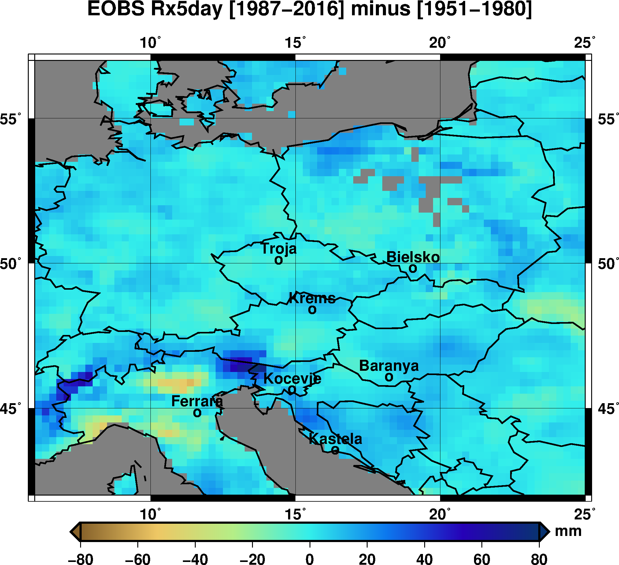
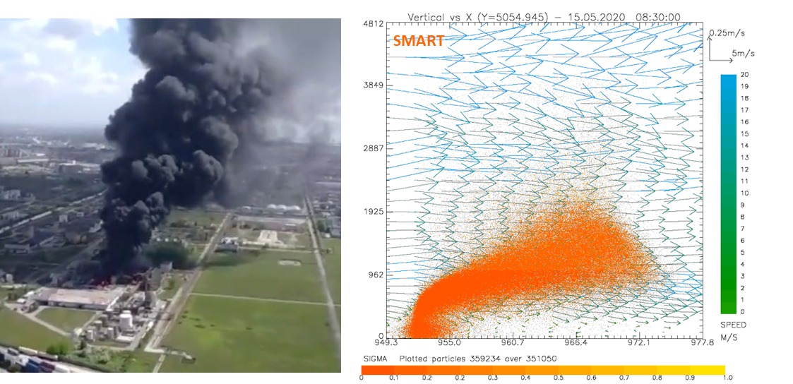
This is shown by the results of a joint study between the Institute of Atmospheric Sciences and Climate of CNR (ISAC-CNR) and Arpa Lombardia. The research, published in Environmental Research, analyzed the concentrations of SARS-CoV-2 in the air in the cities of Milan and Bergamo, studying the interaction with other pre-existing particles.

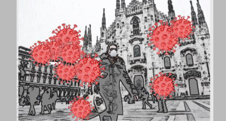
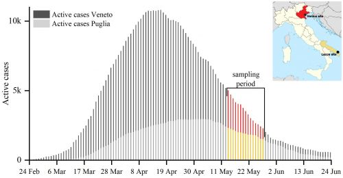
The first wave of the Covid-19 pandemic, during winter of 2020, affected more significantly Northern Italy than the rest of the country and, especially, Lombardia that was the region with the most intense Covid-19 outbreak. As of May 2020, 76,469 cases had been registered there, accounting for 36.9% of the Italian total cases equal to 207,428. The reason why the geographic distribution of the epidemic has been so uneven is still subject of discussion in the scientific community.

A recent study, conducted by the Institute of Atmospheric Sciences and Climate of the National Research Council (CNR-ISAC), Lecce and Bologna divisions, and by the Regional Agency for the Protection of the Environment (Arpa Lombardia), shows that atmospheric particles and virus-laden aerosol do not interact with each other in outdoor air. Therefore, excluding crowded areas, the probability of increased airborne transmission of the infection in outdoor areas with high air pollution appears to be essentially negligible.

The research, published in the scientific Environmental Research journal, was conducted by analyzing data, during winter 2020, in outdoor environments for the cities of Milan and Bergamo, among the most relevant hotspots of COVID-19 in Northern Italy.

“Among the advanced theories, there is the one that relates viral spread and atmospheric parameters, during poor ventilation, atmospheric stability (typical of the winter period in the Po Valley) and atmospheric particulate matter, i.e. solid or liquid particles from natural and anthropogenic sources, present in the atmosphere in high concentrations during the winter period in Lombardia, may favor the transmission in the air (airborne) of the infection,” explains Daniele Contini, researcher of CNR-ISAC (Lecce). “In fact, it has been assumed that these pre-existing particles may act as a vehicle for SARS-CoV-2 by forming clusters with the respiratory emissions of the infected people. In this case, the resulting long-distance transport and the increase of the residence time in the atmosphere of the emitted particulate matter could have promote the airborne spread of contagion”.

In this research, the concentrations of viral particles in the atmosphere of Milan and Bergamo were estimated as function of the number of positive people, both in average terms and in the worst case scenario for the dispersion of pollutants typical of the areas under study. “The results in outdoor public areas show very low concentrations, less than one viral particle per cubic meter of air,” Contini continues. “Even assuming an infected rate of 10% of the population (about 140,000 people for Milan and 12,000 for Bergamo), about ten times more than that currently detected (about 1%), would be necessary, on average, 38 hours in Milan and 61 hours in Bergamo to inhale a single viral particle. However, it must be taken into account that a single viral particle may not be sufficient to transmit the infection and that the average time required to inhale a viral quantum is typically between 10 and 100 times longer than the one related to the single particle, thus varying between tens of days and several months of continuous outdoor exposure. Therefore, the probability of airborne transmission, outside crowded areas, appears essentially negligible”.

“To have, on average, 50% of probability of detecting SARS-CoV-2 in daily samples of PM10 in Milan it would be necessary to have a number of infected people, even asymptomatic, equal to about 45,000 (3.2% of the population) and about 6,300 in the city of Bergamo (5.2% of the population)”, underlines Vorne Giannelle of Arpa Lombardia. “Therefore, at the current state of research, the identification of the new coronavirus in outdoor air does not appear to be an effective method of early warning for pandemic waves”.

“The likelihood that viral particles in the atmosphere form agglomerates with pre-existing particulate matter, of comparable or greater size, is negligible even under the conditions of high pollution typical of the Milan area in winter,” concludes Franco Belosi, researcher at CNR-ISAC of Bologna. “It is possible that the viral particles could form a cluster with nanoparticles much smaller than the virus but this does not significantly change the mass of the viral particles or their residence time in the atmosphere. Therefore, atmospheric particulate matter, outdoors, does not appear to act as a vehicle for the coronavirus”.

F. Belosi, M. Conte, V. Gianelle, G. Santachiara, D. Contini, 2020. On the concentration of SARS- CoV-2 in outdoor air and the interaction with pre-existing atmospheric particles. Environmental Research 110603, https://doi.org/10.1016/j.envres.2020.110603

Link: https://www.sciencedirect.com/science/article/pii/S0013935120315000

CNR Press release https://cnr.it/it/comunicato-stampa/9921

The himalayan aerosol factory

The results of a research on new particle formation at the Nepal Climate Observatory at Pyramid have been published in the journal Nature Geoscience. We observed that large amount of new particles can form in the Himalayan valleys from naturally emitted gaseous precursors and can be transported to high altitudes by the mountain winds and injected into the upper atmosphere. For the first time, this study shows that particle precursor gases are organic compounds emitted by vegetation at lower altitudes.

During transport along the valley, these gases are transformed by photochemical reactions into compounds of very low volatility, which rapidly transform into a very large number of new aerosol particles. These are then transported into the free troposphere, a region of the atmosphere with very low human influence. We can therefore think the whole Himalayas as an ‘aerosol factory’ that continuously produces a large amount of particles and then directly injects them high up into the atmosphere above the Everest”. From these observations, we estimated that wind transport can increase the number of particles by a factor of two or more. These new observations are therefore important to better estimate the pre-industrial concentration for aerosols in this large region.

Biogenic particles formed in the Himalaya as an important source of free tropospheric aerosols. Nature Geoscience, 2020 DOI: 10.1038/s41561-020-00661-5

Misurare la pioggia con un’antenna satellitare domestica? Grazie a NEFOCAST, oggi si può!


I ricercatori ISAC sono stati recentemente coinvolti in un originale progetto per la stima della precipitazione da collegamenti satellitari utilizzati per servizi di  telecomunicazioni.

Il progetto Nefocast, finanziato dalla Regione Toscana, ha l’obiettivo di ottenere informazioni con elevate risoluzione temporale sulle precipitazioni atmosferiche a partire dall’attenuazione dovuta alla precipitazione sulla propagazione dei segnali di telecomunicazione. Come strumento di misura è stato usato lo SmartLNB, un ricevitore satellitare bidirezionale di nuova generazione. Questo ricevitore domestico, progettato e commercializzato per fornire servizi satellitare (es. internet via satellite, TV interattiva, raccolta dati da sensori, Internet of Things), è stato utilizzato dal progetto Nefocast come sensore meteo di opportunità: il ricevitore, infatti, misura il livello di segnale in ingresso e può trasmettere questo dato per ulteriori elaborazioni.

Lungo la tratta satellite-ricevitore il segnale viene attenuato a causa di tanti fattori, ma alle frequenze usate dai terminali SmartLNB, tale attenuazione è dovuta prevalentemente alle precipitazioni meteorologiche. Quindi conoscendo la potenza del segnale ricevuta in caso di precipitazione, è possibile misurare l’attenuazione subita dal segnale e quindi con uno specifico algoritmo appositamente sviluppato durante il progetto è possibile ottenere l’intensità di precipitazione.

I principali vantaggi e potenzialità del sistema possono essere riassunti quali:

  • Stima della precipitazione a costo «zero» (si utilizzano segnali e sistemi di opportunità), real-time e con elevata risoluzione temporale
  • Stima areale con accuratezza crescente al crescere della densità della rete di smartLNB
  • Qualità omogenea del dato
  • Potenziale grande disponibilità di dati a livello mondiale, in particolare in zone densamente popolate
  • Facilità di installazione e gestione in zone remote o dove i dati di precipitazione sono nulli o scarsi

Durante il progetto l’algoritmo di retrieval è stato sviluppato, ottimizzato e validato attraverso una campagna di misura che ha permesso di analizzare nel dettaglio la performance del sistema con il confronto con le misure effettuate da strumenti convenzionali per la misura della precipitazione al suolo quali disdrometri e pluviometri. I risultati della validazione sono incoraggianti e mostrano come il sistema proposto nel progetto Nefocast e basato su smartLNB sia un sistema innovativo per la stima della precipitazione. Alcuni limiti tecnici, quali la ridotta dinamica di misura e le scarse performance in caso di precipitazioni di tipo convettivo, sono stati individuati e sono state evidenziate le possibili soluzioni.

Il progetto ha visto la collaborazione di aziende private (MBI s.r.l. come capofila e Pro.Ge.Com. s.r.l.) e ricercatori di diversi enti di ricerca italiani (Cnr, Università di Pisa, Univerità di Firenze, Cnit).

La ricerca è stata di recente pubblicata su IEEE Transaction on Geosciences and remote sensing, ed è firmata da: Elisa Adirosi, Luca Baldini (Cnr-Isac), Alessandro Mazza e Alberto Ortolani (Cnr-Ibe), Luca Facheris (Dipartimento di Ingegneria dell’Informazione, Università di Firenze), Filippo Giannetti e Simone Scarfone (Dipartimento di Ingegneria dell’informazione, Università di Pisa), Giacomo Bacci (MBI s.r.l.)

Contatti Elisa Adirosi: elisa.adirosi@artov.isac.cnr.it

Special Issue “Satellite Microwave Remote Sensing for Severe Storms Detection”

The last two decades have seen significant increasing precipitation products from satellite microwaves. New architectures of passive and active satellite sensors provided accurate measurements of precipitation by improving the retrieval of frozen hydrometeors. Currently, a wide range of microwave sensors orbiting around the Earth offers an unprecedented opportunity to investigate precipitating systems by identifying cloud-scale details useful to better classify cloud types and evaluate the severity degree of storms.

This Special Issue will publish contributions from research, operational products, and data assimilation capabilities of microwave satellites used in support of the investigation of severe storms. Studies that address connections with essential climate variables are particularly welcome. Contributions from CubeSat applications and theoretical studies with new microwave sensors onboard future satellite missions are also strongly encouraged.

Deadline for manuscript submissions: 28 February 2022

For further details, please, visit the web page: www.mdpi.com/si/69177

SARS-CoV-2, How to prevent indoor infection

Maintaining the right degree of humidity and adequate air exchange prevents the spread of the virus in indoor environments, especially where the risk is higher, such as hospitals and medical practices. This is confirmed by an international study conducted, among others, by CNR-Isac researchers and published in the International Journal of Environmental Research and Public Health (https://www.mdpi.com/1660-4601/17/22/8553).

It is well known that Sars-Cov-2 is not only transmitted by direct contact, but it can spread through the air by “droplets”, the droplets of nebulized saliva. “Although the virus itself is about a hundred nanometers in size (the diameter of a hair is 50,000-180,000 nanometers), it has been verified that an infected person, through breathing, vocalization, coughing, sneezing, can emit an aerosol potentially containing SARS-CoV-2,” explains Francesca Costabile, researcher at the Institute of Atmospheric Sciences and Climate of the National Research Council (CNR-Isac).

A study published in the International Journal of Environmental Research and Public Health by Cnr-Isac, in collaboration with the German Leibniz Institute for Tropospheric Research, the CSIR- National Physical Laboratory of India and 2B Technologies- Boulder (USA), suggests appropriate strategies to prevent and mitigate the risk of airborne transmission of the virus. “In addition to their composition, the particles of these aerosols vary considerably in size, from less than 1,000 nanometers, the diameter of particulate matter, to values greater than 5,000 nanometers, the size of typical respiratory droplets,” Costabile continues. “The relationship between inhaled dose and infectivity for SARS-CoV-2 strongly depends on the size: the ability to penetrate the lower respiratory tract, systemic translocation throughout the human body and attack on particularly vulnerable target organs, first of all the brain”.

The risk, in short, varies drastically with the size of these aerosol particles. “Inspired by the precautionary principle, the main objective of the work was to recognize, based on already published data, the existence of a risk due to the possible airborne transmission of SARS-CoV-2 in particular indoor environments. And therefore propose simple and clear guidelines to hospitals, medical practices, public places and other similar environments”, warns the researcher Cnr-Isac. “Robust laboratory results show that the virus transmission, in environments without solar radiation, is favoured by dry and cold conditions. On this basis – indoors with direct cold, dry, direct sunlight and insufficient ventilation – we recommend first of all: to maintain adequate humidification of the indoor air (in the range 40-60%), especially when temperatures are below 20°C, the use of air purifiers, adequate mechanical ventilation even in winter periods and the measurement of the concentration of carbon dioxide (CO2) in the air, to be maintained below 1000 ppm. Finally, we do not recommend the use of nebulizers in some medical procedures and types of disinfectants for cleaning such as hydrogen peroxide. In the absence of these precautions the risk could remain even if wearing the surgical mask”.
These guidelines aim to reduce the risk of airborne transmission, for example in hospitals and nursing homes, as there are still few countries such as Canada, Belgium and Switzerland that have adopted strategies against the potential risk of airborne transmission of SARS-CoV-2, thanks to the support of scientists. “We believe that this is one of the most important tasks for research at this particular time,” Dr. Costabile concludes. “Our study represents one of the results of the line of research outlined within the CNR-Isac with the creation of thematic working groups dedicated to Covid-19 in the lockdown period”.

Interview: Rai UnoMattina Dec. 8, 2020 from min 23.57  https://www.raiplay.it/video/2020/11/Unomattina-ecdfe3b8-fa38-4c9c-9dd2-a912a95d2c78.html

Publication: Strategies for prevention and mitigation of airborne transmission risk of Sars-Cov-2 Ahlawat, A.; Mishra, S.K.; Birks, J.W.; Costabile, F.;Wiedensohler, A. Preventing Airborne Transmission of SARS-CoV-2 in Hospitals andNursing Homes. Int. J. Environ. Res. Public Health 2020, 17, 8553. https://www.mdpi.com/1660-4601/17/22/8553

Contacts: Francesca Costabile, Cnr-Isac, francesca.costabile@artov.cnr.it 

ArteScienza – Cambiamenti Climatici: antichi saperi e nuove tecnologie per la difesa del nostro patrimonio culturale e paesaggistico

A seguito del convegno “ArtEclima: tra emergenze e difesa dei nostri Beni Culturali” (Senato della Repubblica, 21 Settembre 2020) sono stati organizzati dalla senatrice Michela Montevecchi, membro della commissione Cultura di Palazzo Madama, due eventi sul tema dell’impatto dei cambiamenti climatici sul patrimonio culturale e paesaggistico con la partecipazione di esperti rappresentanti delle istituzioni, del mondo accademico, della ricerca e dell’impresa.

Nel primo modulo (30 novembre 2020) gli speaker hanno fatto emergere chiaramente il ruolo di eccellenza della ricerca italiana nel panorama internazionale nel settore della tutela del patrimonio artistico, del paesaggio e delle opportunità fornite dalle nuove tecnologie per mitigare e contrastare gli impatti negativi generati dalla crisi climatica.

Alessandra Bonazza, coordinatrice dello studio “Safeguarding Cultural Heritage from Natural and Man-Made Disasters”, ha presentato le attività condotte in ISAC per rafforzare la resilienza del patrimonio culturale attraverso la ricerca sulla vulnerabilità, sull’individuazione delle aree di rischio e sull’uso dei dati satellitari.

L’opinione pubblica non è pienamente cosciente dell’impatto di questa emergenza climatica, largamente preannunciata e da affrontare senza temporeggiamenti, e pertanto anche la politica risulta ancora distante dalle tematiche di mitigazione, dalle strategie e dai piani adattamento, dalle politiche integrate di sviluppo sostenibile.

Scienza e politica si trovano in queste occasioni a condividere temi e soluzioni, la comunità scientifica è a disposizione per fornire gli strumenti sviluppati dalla propria ricerca, ma è necessario che la politica ascolti i suggerimenti e metta questi temi al centro dell’agenda del nostro Paese, nonostante le poche risorse stanziate dalla legge di Bilancio nell’esercizio finanziario 2020 per la categoria ‘Cultura, ambiente e qualità dell’aria’.

Riferimenti
– Glasgow Action Plan lavoro svolto nell’ambito della COP25 dal ‘Madrid-to-Glasgow Arts, Culture and Heritage Climate Action Plan’, lanciato dal Climate Heritage Network 

– “Safeguarding Cultural Heritage from Natural and Man-Made Disasters” studio CNR-ISAC

– “Future of Our Pasts: Engaging Cultural Heritage in Climate Action” rapporto ICOMOS

Notte Europea dei Ricercatori, 27 novembre 2020

Quest’anno potete rimanere comodamente sul divano e passare da un evento realizzato a Bologna a quello registrato a Lamezia Terme semplicemente con un paio di click sulla tastiera. Tutti i progetti finanziati per il 2020 dalla Commissione Europea sono stati infatti realizzati online – 27 Novembre 2020. 
Consultate i programmi, registrarvi alle piattaforme se richiesto e godetevi lo spettacolo realizzato da ISAC per il 2020:

NET – Coordinato dal CNR, la sede ISAC – Roma ha virtualmente aperto la sua base di misura per far conoscere i mezzi con i quali i ricercatori studiano i vari aspetti dell’atmosfera (L. Di Liberto, F. Barnaba, M. Campanelli, G. Casasanta, S. Federico, L.P. D’Adderio, E. Adirosi, F. Prestileo e M. Montopoli). Parteciperà inoltre a Storie di ricercatori (F.Cairo) e ad un NET Talk, trasmesso in esclusiva su Raiplay dalle ore 19.00, sul tema “Antartide, la terra oltre i limiti” (G. Casasanta). La sezione Documentari ospita il video del progetto ProteCHt2save sul patrimonio culturale a rischio per eventi estremi.

 https://www.scienzainsieme.it/


SUPERSCIENCEME – Coordinato dall’Università della Calabria, ISAC – la sede di Lamezia Terme apre le porte dell’Osservatorio climatico I-AMICA e rende disponibili, sulla piattaforma online, video appositamente realizzati sulle seguenti tematiche:
– Un osservatorio per il clima nel centro del Mediterraneo a Lamezia Terme? (C.R. Calidonna, T. Lo Feudo, I. Ammoscato, D. Gulli, video girato presso Osservatorio I-AMICA di Lamezia Terme),
– Cosa serve per osservare il clima e la salute del pianeta Terra? (C.R. Calidonna, T. Lo Feudo, I. Ammoscato, D. Gulli),
– I modelli meteorologici e le previsioni meteo (E. Avolio),
– Il clima e i suoi cambiamenti (T. Lo Feudo),
– Futuri climatologi (T. Lo Feudo),
– Dalla ricerca all’impatto sull’ambiente delle misure chimico –atmosferiche: clima, qualità dell’aria, rischio idrogeologico e incendi, salute (C.R. Calidonna, T. Lo Feudo, I. Ammoscato, E. Avolio, M. Iannone CNR-IRIB, video e interazione live)

http://superscienceme.it/


ERN APULIA – Coordinato dall’Università del Salento, ISAC – sede di Lecce parlerà attraverso video e webinar desi seguenti temi:
– Analisi dell’eruzione dell’ETNA 2015 utilizzando il modello WRF-Chem e osservazioni satellitari (U. Rizza, video delle simulazioni),
– E’ quasi notte…Una giornata di lavoro in Artico (A. Donateo, P. Ielpo, F. Scoto, video girato presso la base di Gruvebadet – Ny Alesund),
– X Med-Dry: una rete di deposizioni secche nel bacino del Mediterraneo (P. Ielpo, F. De Tomasi, K. Kandler, video girato presso la stazione di monitoraggio di Lecce),
– Come migliorare le previsioni meteorologiche grazie ai dati di fulmini (A. Comellas Prat, S. Federico, R. C. Torcasio, S. Dietrich, video),
 Moviola della simulazione modellistica del tornado di Taranto del 2012 (M. Miglietta, video della simulazione),
– Ambiente e Clima. Il presente per il futuro (C. Mangia),
– Viaggio di una gocciolina in un colpo di tosse (P. Martano, video),
– Media oraria della colonna totale di ozono simulata con il modello WRF-Chem in dominio artico (U. Rizza e P. Ielpo, M. Morichetti, video della simulazione).

http://www.ern-apulia.it/

SOCIETYNext – Coordinato dal CINECA, ISAC – Bologna, dopo aver contribuito con propri interventi e tour alle rassegne “Aspettando la notte dei ricercatori” e “Quattro chiacchiere con la scienza”, partecipa alla notte con un Laboratorio virtuale sul tema Meteorologia e clima: che fenomeni! (A. Marinoni, S. Davolio e M. Paglione) e con incontri a tu per tu (speed date) con i ricercatori (M. Brunetti, P. De Nuntiis, M.D. Fernandez Gonzalez, V. Lembo, A. Marinoni) con i quali poter interagire facendo domande sulle tematiche di ricerca proposte.
Necessario registrarsi ed accedere alla piattaforma https://notte-dei-ricercatori.sharevent.it/it-IT/

http://nottedeiricercatori-society.eu/


Per vedere nel sito ISAC le precedenti edizioni  clicca QUI

Can Coronavirus be in the Air? Only in the crowded areas

A multidisciplinary study, conducted in May 2020, analyses the atmospheric concentrations of SARS-CoV-2 in Venice and Lecce, highlighting the implications for airborne transmission. The study, published in Environment International, was conducted by Cnr-Isac, Ca’ Foscari University of Venice, Cnr-Isp, and Istituto Zooprofilattico Sperimentale della Puglia e della Basilicata.

The rapid spread of SARS-CoV-2, and the generation of outbreaks with different intensity in different regions of the same country, raised important questions regarding the mechanisms of transmission and the role potentially played by airborne transmission. While the transmission of SARS-CoV-2 by contact (direct or indirect via contact surfaces) is widely accepted, airborne transmission is still controversial, especially in outdoors. The multidisciplinary study, conducted by the Institute of Atmospheric and Climate Sciences of the National Research Council (CNR-Isac) of Lecce, the University Ca’ Foscari Venezia, the Institute of Polar Sciences of the CNR (CNR-Isp) of Venice, and the Istituto Zooprofilattico Sperimentale della Puglia e della Basilicata (Izspb), allowed to analyse concentrations and size distributions of viral particles in outdoor air collected simultaneously during the pandemic in Veneto and Puglia in May 2020, between the end of the lockdown and the resumption of activities.

The research, started in the framework of the project “AIR-CoV (Evaluation of the concentration and size distribution of SARS-CoV-2 in air in outdoor environments) and published in the scientific journal Environment International, showed a low probability of airbone transmission in residential and urban areas, with the possible exclusion of crowded outdoor sites. “Our study examined two cities with different diffusion of COVID-19: Venice-Mestre and Lecce, located in two parts of the country (northern and southern Italy) characterized by very different rates of spread of COVID-19 in the first phase of the pandemic,” explains Daniele Contini, CNR-Isac researcher. During the first phase of the pandemic, the spread of SARS-CoV-2 was exceptionally severe in Veneto region, with a maximum of active cases (i.e. infected individuals) of 10,800 at 16 April 2020 (about 10% of the total Italian cases) out of a population of 4.9 million. Instead, Apulia region reached the maximum of active cases on May 3, 2020 with 2,955 cases (3% of total Italian cases) out of a population of 4.0 million people. At the beginning of the measurement period (May 13, 2020), the Veneto and Puglia regions were affected by 5,020 and 2,322 active cases, respectively.

“The role of airborne transmission depends on several variables such as concentration and size distribution of viral particles in the atmosphere and meteorological conditions. These variables can differ in outdoor and indoor environments,” emphasizes Marianna Conte, Cnr-Isac researcher.

The potential existence of SARS-CoV-2 virus in aerosol samples analyzed was determined by collecting atmospheric particulate matter of different sizes from nanoparticles to PM10 and determining the presence of SARS-CoV-2 genetic material (RNA) with advanced laboratory diagnostic techniques. “All samples collected in residential and urban areas in both cities were negative, the concentration of viral particles was very low in PM10 (less than 0.8 copies per m3 of air) and in each size range analyzed (less than 0.4 copies per m3 of air)”, Contini continues. “Therefore, the probability of airborne transmission of the contagion outdoors, excluding those very crowded areas, appears very low, almost negligible. In crowded sites, concentrations can increase locally as well as risks due to close contacts, therefore it is absolutely necessary to respect the regulations enforced for avoiding crowds”.

“A higher risk could be present in indoor environments of poorly ventilated communities, where the smaller respiratory droplets can remain in suspension for longer periods of time and also settle on surfaces,” stresses Andrea Gambaro, professor at Ca’ Foscari. “It is therefore desirable to mitigate the risk through the periodic ventilation of environments, the sanitation of hands and surfaces and the use of masks”.

“The study and application of sensitive analytical methods with the use of technologically advanced platforms allow, today, to detect the presence of Sars-CoV-2 even at very low concentrations, as it could be in outdoor and indoor environments, making laboratory diagnostics more and more reliable” concludes Giovanna La Salandra, Manager of the Izspb Research and Scientific Development Structure. The concentrations in some indoor community environments will be studied in a second phase of the AIR-CoV project.

D. Chirizzi, M. Conte, M. Feltracco, A. Dinoi, E. Gregoris, E. Barbaro, G. La Bella, G. Ciccarese, G. La Salandra, A. Gambaro, D. Contini, 2020. SARS-CoV-2 concentrations and virus-laden aerosol size distributions in outdoor air in north and south of Italy. Environment International 106255, https://doi.org/10.1016/j.envint.2020.106255
Link open access: https://authors.elsevier.com/sd/article/S0160412020322108

CNR Press release https://www.cnr.it/it/comunicato-stampa/9830

A New Method for Hail Detection from the GPM Constellation

CNR-ISAC researchers, have developed a method to identify the signal-emitted by hailstones inside the storms and monitor the evolution of hail clouds with high temporal rate. The study, carried with the collaboration of US research team of the National Oceanic and Atmospheric Administration (NOAA) and the University of Maryland, will allow to better understand the distribution of frozen hydrometeors inside the thunderstorm improving the current knowledge on the formation mechanisms of hail clouds in a changing climate. The proposed method (MWCC-H) exploits the capability of high frequency microwaves in the range 150-170 GHz to identify the hail signature from the precipitating systems. The strength of this study is having developed the first generalized method able to work with the all high frequency radiometers aboard the Global Precipitation Measurement mission (GPM) constellation.  

Conceptually, the approach is based on a Verhulst-type probabilistic growth model, in which the growth of a biological population is self-limited by a series of factors necessary to control the population explosion. The model by evaluating the perturbation induced by the storms to the natural radiation field emitted from the Earth (unperturbed field) detects the scattering signals from the icy hydrometeors by extracting the hail signatures. The signal depression measured to the satellite tends to be distributed accordingly an exponential law as a function of hail size distribution. Uncontrolled growth leads to the explosion of the model (critical or saturation condition). Then, similarly to the biological population, the MWCC-H model is self-regulating through the parameter K (carrying capacity), which controls the growth of the curve until saturation conditions are reached.

Validation results demonstrate the robustness and sensitivity of the method in reproducing hail clouds and distinguishing small areas inside the storms where hail formation mechanisms begin to activate.

The greatest utility of this method is giving the unprecedented possibility to monitor the evolution of hailstorm systems with very high temporal resolution (see figure). The validity of this study is also increased by the opportunity to create a homogeneous database of hailstorm events at the global scale on each type of surface. Such database is an extremely useful tool for improving the current knowledge of the effects of climate change on the formation of solid precipitation and on the space-time location of the most intense storm systems.

Laviola S., G. Monte, V. Levizzani, R. R. Ferraro, and J. Beauchamp: A New Method for Hail Detection from the GPM Constellation: A Prospect for a Global Hailstorm Climatology. Remote Sens. 2020, 12(21), 3553; https://doi.org/10.3390/rs12213553.


CNR Press release https://www.cnr.it/it/news/9786

Dedicated to Hans Pruppacher’s memory from Vincenzo Levizzani

Prof. Dr. Hans Rudolf Pruppacher

23 March 1930 – 11 October 2020

Hans Pruppacher, a giant of the atmospheric sciences, has left us a few days ago leaving behind a sense of loss not only for his scientific contributions, but also for his humanity and tremendous skills as mentor. Hans was the most representative scientist in a field, cloud physics, where he played a fundamental role as scientist, teacher and mentor of generations of students and collaborators.

Visit http://www.cloudysky.it/Hans.html for the complete text.

La Cina ecologica che surriscalda il Pianeta

il Venerdì, supplemento de La Repubblica, del 30 ottobre 2020 pubblica l’articolo “La Cina ecologica che surriscalda il Pianeta”.
Sandro Fuzzi CNR-ISAC interviene in merito all’enorme sforzo che la Cina sta facendo per limitare l’inquinamento atmosferico. Per paradosso, la forte diminuzione della concentrazione di particolato atmosferico in aria, fortemente benefica per la salute della popolazione, sta causando un aumento della temperatura del pianeta dato che il particolato atmosferico agisce da agente “raffreddante” del clima. Per questo si rende necessaria una ancora più decisa diminuzione delle emissioni di CO2 e degli altri composti clima-alteranti.

Institutional visit by the regional councillor Sandra Savaglio to the CNR-ISAC headquarter in Lamezia Terme: “Calabrian excellence”

The Regional Councillor for Research, University and Education of the Calabria Region Sandra Savaglio visited the ISAC headquarter in Lamezia Terme.

The visit allowed the councillor, an internationally renowned scientist, to learn more about the research activities carried out in the institute: from the measurements of natural and anthropogenic sources, useful for the observation of polluting and climate-altering dynamics, to specific atmospheric studies related to intense weather events.

They have been illustrated the activities of the Environmental Climate Observatory which contributes, together with 500 other observatories around the world, to the Global Atmospheric Watch of the World Meteorological Organization (Gaw-Wmo), for monitoring the state of the climate at a global level.

“Remain in Calabria – says Councillor Savaglio – can and must be done. Getting to know the many excellent realities more closely serves above all to guide our young people to stay and to invest in study and work for collective growth ».

Full article here

Researches in Antarctica: Isac still present

For the seasonal reopening of the Zucchelli base in Antarctica, among the 5 CNR researchers who took part in this year’s expedition, there is Dr. Alessandro Bracci Cnr-Isac associate researcher, PhD student at the University of Bologna who works on multidisciplinary issues focused on the microphysics of precipitation.

Dr. Bracci was recently interviewed by the journal Green blue in an interesting article that highlights the role of Italian scientists in Antarctica: among penguin mummies, melting ice and anti-Covid measurements”.

Full article can be found  here


Snowfall over the ice-free ocean: what we can learn from the latest frontiers researches

The CloudSat 94 GHz radar provides the most complete snowfall climatology over polar regions, but accurate quantitative snowfall estimates derived from radar reflectivity (figure in the preview) remain challenging. The published work  explores the value of the CloudSat 94 GHz Brightness Temperature, a novel product developed from the processing of the radar noise floor level, combined with path-integrated attenuation, a standard product derived from the reduction in the radar surface return.

Results demonstrate that over ice-free ocean, where surface emissivity and backscattering are well predictable, the synergistic use of these two observables provides crucial information on the presence/amount of supercooled layers and on snow density, with potential for better constraining snowfall retrieval. 

The published paper has gained the cover of the MDPI Remote Sensing journal

Paper link:  https://www.mdpi.com/2072-4292/12/20/3285

Battaglia, A.; Panegrossi, G. What Can We Learn from the CloudSat Radiometric Mode Observations of Snowfall over the Ice-Free Ocean? Remote Sens. 202012, 3285.

Special Issue “Remote Sensing of Water Cycle ECVs and their Applications”

The focus of this Remote Sensing of the Water Cycle Special Issue is on remote sensing-related Essential Climate Variable – Climate Data Records (ECV-CDRs) of all water cycle components and their applications. Submitted manuscripts will preferably report scientific advances in the following topics, but other topics related to the scope of the SI will also be considered:

  • New water cycle CDRs: development and generation procedures;
  • Validation, capability assessment, and intercomparisons of water cycle CDRs;
  • CDR exploitation in long-term analyses: regional climatology, variability and trends, extreme event projections;
  • Droughts and floods: climatology and climatic driver identification;
  • Capability of CDRs to capture extremes;
  • Water cycle CDR exploitation in climate services for societal benefits;
  • Exploratory studies of the connections among the water cycle, agriculture and food, public health, and energy.

Deadline for manuscript submissions has been postponed: 31 March 2021

For further information, please, visit the web site: 

https://www.mdpi.com/journal/remotesensing/special_issues/ECV_WaterCycle


SPECIAL ISSUE “REMOTE SENSING OF THE WATER CYCLE IN MOUNTAIN REGIONS”

The Guest editor Elisa Palazzi (CNR-ISAC), together with the colleague Joerg Bendix of the University of Marburg, announces the Special IssueRemote Sensing of the Water Cycle in Mountain Regions” of Remote Sensing (ISSN 2072-4292, IF 4.118).
Anyone interested is invited to submit works on the following topics by 30 June 2021:

– Water cycle

– Remote sensing

– Elevation dependent warming

– Cloud and rainfall changes in mountains

– Elevation dependent climate change, including extremes

– Mountain ecosystems

– Biodiversity loss

– Ecosystem services, nature contributions to people (NCP)

Please visit the Special Issue website: https://www.mdpi.com/journal/remotesensing/special_issues/water_mountain.

Special Issue “New Insights into Atmospheric Chemistry and Climate”

The Guest editor Pierina Ieplo (CNR-ISAC) announces the Special Issue “New Insights into Atmospheric Chemistry and Climate” of Applied Sciences (ISSN 2076-3417) belonging to the section “Environmental and Sustainable Science and Technology”.
The topics of interest for this Special Issue include, but are not limited to the following:

  • carbonaceous aerosol
  • black carbon natural and anthropogenic sources identification in different regions
  • secondary inorganic and organic aerosol (SIA, SOA) formation from anthropogenic and natural precursor gases
  • aerosol-cloud interactions
  • assessment of source‘s contribution and composition by tracer-based and ensemble-based source apportionments
  • comparison and merging of remote sensing and ground-level measurements and transport models output
  • numerical models of aerosol transport
  • aerosol optical properties
  • Humic Like Substances (HULIS)

Deadline for manuscript submissions: 31 December 2020

Guest editors
Dr. Pierina Ielpo 
Prof. Dr. Paola Fermo
Dr. Constantini Samara

https://www.mdpi.com/journal/applsci/special_issues/Atmospheric_Chemistry_Climate


Satellite precipitation estimate of Medicane Ianos from H SAF products developed at ISAC

On September 14-20, 2020, a Mediterranean cyclone with tropical-like characteristics, commonly known as “Medicane” swept across the South-eastern Mediterranean basin. The Medicane named Udine, according to the official denomination given by the University of Berlin, hit the coasts of Sicily and Calabria and made landfall on the western coasts of Greece on September 18th, 2020.  Sixty to ninety overpasses by the microwave sensors in the Global Precipitation Measurement (GPM) constellation (https://www.nasa.gov/mission_pages/GPM/main/index.html) allow to characterise and monitor the evolution of the precipitation of Medicane Udine throughout its evolution over the Mediterranean Sea.

The CNR-ISAC activity within the EUMETSAT Satellite Application Facility on Support to Operational Hydrology and Water Management (H SAF) (http://hsaf.meteoam.it/)  consists in developing and providing satellite precipitation products in support of Operational Meteorology, Hydrology, Oceanography and Risk Management. Two H SAF products for Medicane Udine are shown. The H67 product is a Level 3 (gridded) passive microwave (PMW) precipitation product, providing 24 hours mean precipitation rate on a regular grid (0.25° spatial resolution) based uniquely on the exploitation of MW radiometers. H67 product estimated the rainfall during the Medicane Udine showing a peak higher than 400 mm with a wide area with more than 100 mm. Moreover, the operational H03B product provides instantaneous precipitation rate generated from the geostationary MSG SEVIRI IR measurements “calibrated” by precipitation estimates from MW radiometers on board LEO satellites, processed soon after each SEVIRI acquisition (“Rapid Update”). H03B with a temporal resolution of 15 minutes and a spatial resolution of about 4 km (at the location of Medicane Udine) allows to continuously monitor the precipitation.

Contacts: Giulia Panegrossi CNR-ISAC, H SAF Science Coordinator  (g.panegrossi@isac.cnr.it)

Il clima per costruire lo spirito di gruppo

Per la prima volta nella storia degli osservatori ISAC, le infrastrutture del Monte Cimone e il Sentiero dell’Atmosfera sono state utilizzate per un’attività aziendale di team building. Si tratta di una nuova prospettiva di collaborazione tra mondo della ricerca e dell’industria, che trova il suo compimento nella realizzazione di un’attività di sensibilizzazione come veicolo per la coesione aziendale. Questa attività potrebbe aprire a nuove forme di collaborazione, stimolando un tipo di flusso di informazioni che altrimenti rischia di diventare di difficile realizzazione per i più.

SMART simulation of the fire in the harbour of Ancona on September 16th 2020

As done for the accident in Marghera on past 15th of May (http://www.isac.cnr.it/en/news/smart-simulation-fire-3v-sigma-plant-marghera-venice-may-15th-2020), also the recent fire occurred in the harbour of Ancona has been simulated with SMART modelling suite, as new test case. The emission term has been elaborated by ARIANET Srl. The release starts at 23 UTC on 15th September.

The modelling system SMART is under development for the simulation of accidental releases dispersion. SMART is composed by the non-hydrostatic atmospheric model MOLOCH (here run at 500 m horizontal resolution), interfaced to the Lagrangian stochastic particle dispersion model SPRAY, through the new ARAMIS code.

The new suite is planned to be adopted as a tool for emergency response purposes in any part of the Italian territory at any time.


SMART – Spray-Moloch Atmospheric Regional Tool

Contacts:  Silvia Trini Castelli, Piero Malguzzi

http://www.isac.cnr.it/en/numerical_models/smart


Intervista a 1 Mattina – Rai1

A Unomattina – Rai1, mercoledi’ 16 2020, una intervista di Enrico Ferrero, Universita’ del Piemonte Orientale e associato di ricerca ISAC, sul problema della siccita’

link RaiPlay al minuto 42

Premio Pegaso per l’Ambiente 2020

E’ stato conferito alla ricercatrice ISAC Cristina Mangia il Premio Pegaso per l’Ambiente 2020 per la sua intensa attività di ricerca finalizzata allo studio del clima e dell’ambiente.

Il Premio Pegaso per l’Ambiente è promosso dall’Associazione ATA-PC Lecce per conferire un riconoscimento a coloro che, sul territorio nazionale e locale, si sono distinti in particolari azioni rivolte alla tutela e alla salvaguardia dell’ambiente e degli animali.
 

A FORUM for the climate

The paper “FORUM: unique far-infrared satellite observations to better understand how Earth radiates energy to space”, published on the Bulletin of the American Meteorological Society, written by Dr. Luca Palchetti of CNR-INO along with an international team, with Dr. Bianca Maria Dinelli of CNR-ISAC among the authors, describes the FORUM (Far-infrared Outgoing Radiation Understanding and Monitoring) mission selected September of last year to be the ESA Earth Explorer 9. FORUM will observe from space, for the first time, the Earth’s outgoing radiation spectrum across the far-infrared with high spectral resolution and accuracy. The Earth Outgoing Longwave Radiation (OLR) emitted to space, to which numerous physical processes contribute, is a fundamental component of the Earth’s energy budget, strictly linked to climate change.

Palchetti, L., and Coauthors, FORUM: unique far-infrared satellite observations to better understand how Earth radiates energy to space. Bull. Amer. Meteor. Soc., 2020, doi: https://doi.org/10.1175/BAMS-D-19-0322.1.

Figure: Spectrum of the outgoing radiance expected at TOA for clear sky (blue line) under a mid-latitude standard scenario and in presence of a cirrus cloud (grey line). The spectral ranges covered by FORUM and IASI-NG are also shown. 

Atmospheric River in the Mediterranean

The paper recently published on the Monthly Weather Review, by CNR-ISAC scientists Silvio Davolio, Mario Miglietta, Sante Laviola e Vincenzo Levizzani together with Stefano Della Fera (University of Bologna), describes the physical mechanisms leading to extreme precipitation over Italy at the end of October 2018, associated with the storm “Vaia”. The study identifies the presence and the critical role of an Atmospheric River over the Mediterranean, that is a transport of a huge amount of moisture from the tropics within a long and narrow corridor across the African continent, in feeding the intense rainfall.

Link: Davolio S. et al., 2020: Heavy Precipitation over Italy from the Mediterranean Storm “Vaia” in October 2018: Assessing the Role of an Atmospheric River. Mon. Wea. Rev., 148 (9), 3571-3588. https://journals.ametsoc.org/mwr/article/148/9/3571/353237/Heavy-Precipitation-over-Italy-from-the

Figure: Integrated water vapour transport (kg m−1 s−1) and geopotential height at 500 hPa

Il Cnr contribuisce al primato italiano ARWU in “Atmospheric Science” dell’Università dell’Aquila

Nel campo delle “Atmospheric Science” l’Università dell’Aquila è risultata 1° in Italia secondo l’Academic Ranking of World Universities (ARWU, 2020), e nella classifica globale nella fascia 151-200.

ISAC contribuisce in parte a questo risultato con l’insegnamento “Radar Meteorology” (Mario Montopoli), nella Laura magistrale in Atmospheric Science and Technology (LMAST), consorziata con l’Università La Sapienza di Roma e che vede la partecipazione di altri 2 istituti CNR (IMAA e ISMAR).

La Shanghai Ranking Consultancy pubblica la classifica delle università mondiali ARWU per materie dal 2009, si tratta di un’organizzazione indipendente non subordinata ad alcuna università o agenzia governativa.

Vedi anche
News CNR
Comunicato stampa dell’Università dell’Aquila (01/07/2020)
www.corriere.it

Neppure il COVID-19 ha fermato gli studenti del Fermi di Modena

Il CNR-ISAC di Bologna affianca da alcuni anni, in attività di terza missione, le Scuole Secondarie di Secondo Grado del territorio rispondendo alle richieste ministeriali nell’ambito dei Percorsi per le competenze trasversali e per l’orientamento (PCTO) ex Alternanza Scuola Lavoro (ASL). Grazie alla collaborazione con i docenti, vengono proposte dai ricercatori tematiche che i ragazzi affrontano attraverso esperienze formative che uniscono sapere e saper fare, orientando le aspirazioni dei giovani verso il settore della ricerca.
Particolarmente fruttuosa è stata negli anni la collaborazione con l’Istituto Fermi di Modena. Il CNR-ISAC annualmente propone tematiche correlate a progetti di ricerca attivi che gli studenti delle quinte di informatica e telecomunicazioni sviluppano nel secondo quadrimestre come progetti SSH (Students Software House). I ragazzi si impegnano nel realizzare applicazioni e servizi in rete geografica simulando un rapporto professionale con il CNR-ISAC e gli altri interlocutori esterni alla scuola.

Lavorare a distanza ci aveva già messo alla prova e le skype o le telco erano diventate negli anni il nostro modus operandi, per questo quando l’emergenza coronavirus ci ha costretti all’isolamento non è stato traumatico continuare a lavorare, ognuno nella propria abitazione, realizzando anche per l’anno scolastico 2019 -2020 i progetti che i maturandi presenteranno, nei prossimi giorni, durante la sessione d’esame. Le camere degli studenti si sono trasformate in piccole officine e, nonostante le difficoltà nel recuperare hardware necessario, le idee si sono trasformate in strumenti concreti.

I ragazzi hanno affrontato a modo loro, divisi in gruppi e con tematiche simili, le sfide proposte:
1) Particolato Condiviso: realizzazione di una Centralina modulare, a basso costo, per la misura del particolato atmosferico (PM);
2) Allarme Condensa: Allerta funzionamento del sistema anticondensa per la salvaguardia degli affreschi.

Personale CNR-ISAC coinvolto: 1) Francescopiero Calzolari, 2) Paola De Nuntiis con il supporto di Loris Branzanti della Pegasoft Srl.
Professori Fermi: Marco Mescoli, Roberta Severi, Lorena Marassi, Paolo Santinelli.
Studenti 1) Particolato Condiviso: Edoardo Dotti, Riccardo Pancaldi, Stefano Calabretti, Adriano Buffagni; 2) Allarme Condensa: Riccardo Lugli, Lorenzo Palladino, Antonio Derosa, Plata Adarlo, Riccardo Gavioli, Alessandro Pioli, Angelo Accardo.

“Il nostro cielo” spiegato dei ricercatori ISAC su Rai scuola

Ieri 18 Giugno 2020,  su Rai scuola (canale 146),  è andata in onda la prima di tre puntate dedicate all’atmosfera all’interno del programma RAI NEWTON.

I ricercatori ISAC Giampietro Casasanta ed Elisa Adirosi sono stati i protagonosti della puntata il “nostro cielo, la troposfera.”

Il giorno 23 Giugno ore 21:30, sempre su  Rai scuola, programma Newton,  sarà la volta di Francesco Cairo che approfindirà le ricerche legate alla   Stratosfera. 

La puntata “nostro cielo, la troposfera.” è reperibile su Rai play qui


Newton è un programma di Diego Garbati, Francesco Linguiti, Pino Roggero, Davide Coero Borga con la collaborazione di Massimo Bongiorno, Giuseppe Cembalo, Federica De Maria, Mario Ferrari, Daniela Mazzoli,

Mascherine filtranti anti COVID-19

Disponibile una nota tecnica sulle mascherine filtranti elaborata da CNR-ISAC. Vengono prese in considerazione le mascherine diffuse nel corso della recente pandemia di COVID-19, le chirurgiche, le facciali filtranti e quelle “filtranti” in libera vendita, note come mascherine di comunità. 

ARIA CONDIZIONATA E COVID-19

Con l’arrivo dell’estate risulta importante far chiarezza su alcuni aspetti fondamentali relativi al corretto utilizzo degli impianti di condizionamento dell’aria.
In merito agli eventuali rischi sull’utilizzo dell’aria condizionata, dovuti alla pandemia causata dal virus SARS-CoV-2, il CNR-ISAC fornisce una nota tecnica con alcuni accorgimenti validi sia per i condizionatori di tipo Split che per gli Impianti di condizionamento centralizzati.

E’ uscito il secondo numero della newsletter AISAM

E’ con soddisfazione che vi annunciamo l’uscita del secondo numero della newsletter dell’Associazione Italiana di Scienze dell’Atmosfera e Meteorologia (AISAM) di cui ISAC è socio collettivo.

La newsletter vuole essere uno strumento per dar voce alla all’associazione, affinché essa diventi un punto di aggregazione della comunità nazionale delle scienze dell’atmosfera ma anche un riferimento per i più giovani che si vogliono avvicinare a queste discipline.

Per scaricare la newsletter: https://www.aisam.eu/pluginAppObj_11613/download.php?action=download

SMART simulation of the fire at the 3V-Sigma plant in Marghera (Venice) on May 15th 2020

The recent accident – 15th of May 2020 – with a fire at the 3V-Sigma industrial plant in Marghera (Venice) has been simulated with SMART modelling suite, as test case. The emission term has been elaborated together with ARIANET Srl.

The modelling system SMART is under development for the simulation of accidental releases dispersion. SMART is composed by the non-hydrostatic atmospheric model MOLOCH (here run at 500 m horizontal resolution), interfaced to the Lagrangian stochastic particle dispersion model SPRAY, through the new ARAMIS code.

The new suite is planned to be adopted as a tool for emergency response purposes in any part of the Italian territory at any time.


SMART – Spray-Moloch Atmospheric Regional Tool

Contatti: Silvia Trini Castelli, Piero Malguzzi

http://www.isac.cnr.it/en/numerical_models/smart

Does Air Pollution Influence COVID-19 Outbreaks?

Un editoriale scritto dai ricercatori CNR-ISAC Daniele Contini e Francesca Costabile e pubblicato su Atmosphere è oggetto del nuovo comunicato stampa del CNR. L’editoriale analizza, sulla base dei dati disponibili nella letteratura scientifica, l’interazione tra inquinamento dell’aria e Sars-CoV2 ed il meccanismo di trasporto per diffusione in aria senza contatto, mettendo in evidenza i dati noti, le possibili conclusioni e gli aspetti che necessitano di ulteriori studi interdisciplinari.

Per raggiungere un pubblico più ampio, i due ricercatori sono stati poi protagonisti di un video per CNRweb.tv (Trasmissione virus nell’aria: la scienza suggerisce cautela (Video Cnrweb.Tv, 20/04/2020)Il peso dell’inquinamento sul coronavirus (Video Cnrweb.Tv, 20/04/2020)

Link Open Access
Contini D., Costabile F., 2020. Does Air Pollution Influence COVID-19 Outbreaks? Atmosphere 11, 377, doi:10.3390/atmos11040377

An Element of Randomness in Modeling Arctic Ice Cover

Incorporating random perturbations in temperature, humidity, and wind might offer a computationally cheaper alternative to increased resolution in an Earth system model when predicting global warming and Arctic sea ice cover. A Research Spotlight item in Eos Magazine reports findings by ISAC researchers just published in Geophysical Research Letters

Satellite Precipitation Measurement

V. Levizzani, C. Kidd, D. B. Kirshbaum, C. D. Kummerow, K. Nakamura, and J. Turk are the editors of the new Springer’s book “Satellite Precipitation Measurement”. The book offers a complete overview of the measurement of precipitation from space including the advancements of science and technology achieved during the last two decades. Thanks to the unique contributions from field experts and from the International Precipitation Working Group (IPWG, http://ipwg.isac.cnr.it/), the current satellite programs are described together with the major precipitation products, their validation, and applications. Studies focusing on the observed characteristics of precipitation and planning for future satellite missions complete the treated topics. 

https://www.springer.com/it/book/9783030245672 

https://www.springer.com/it/book/9783030357979

La pandemia ci divide, ma la scienza non smette di unirci

Isolati, ma uniti per porsi le giuste domande e programmare insieme percorsi di ricerca che possano offrire un contributo al periodo pandemico che stiamo vivendo. Questa è la risposta che ISAC mette in campo al tempo del COVID-19: i ricercatori, ognuno dalla propria abitazione, si sono riuniti più volte e si sono interrogati su come poter affrontare una tematica così complessa; sono stati individuati tre filoni principali definiti sulla base delle affinità con le tematiche di ricerca condotte in ISAC nelle tre macroaree (IMPEACHCAMEOCAFCA). 
Sono stati attivati 3 gruppi di lavoro specifici, operativi ed interdisciplinari, che partendo dai ricercatori ISAC possano includere competenze diverse come quelle di virologi, epidemiologi, microbiologi, etc. Di seguito trovate per ogni WG la posizione ufficiale ISAC. 
WG1 – Air quality and COVID-19 
WG2 – COVID-19 transmission and aerosol in outdoor and indoor    
WG3 – COVID-19  and meteo-climatic variables 

Invitiamo i ricercatori di università, istituti di ricerca pubblici e privati, istituzioni a contattarci per discutere di un’eventuale collaborazione. Se siete interessati a partecipare scrivete a resp-impatti@isac.cnr.it

Monte Cimone observations in a press release by WMO

The observations of the ISAC-CNR station of Monte Cimone, part of the GAW (Global Atmosphere Watch) network, have been used for the preparation of a press release by the WMO (World Meteorological Organization): it is too early to draw definitive conclusions on the importance of decreases recorded in March 2020 as regards concentrations of greenhouse gases, but be careful of the post-crisis and not to forget Climate Actions. The preliminary observations of Monte Cimone indicate average values lower than those of the previous years both for fine particulate matter and for ozone, but there are many issues to consider to define a quantitative assessment of the impact of the decreased emissions on concentrations at Monte Cimone.

Il ministro Costa due giorni con il Cnr alle Svalbard

QUESTA DOVREBBE ESSERE IN INGLESE


Il Ministro dell’Ambiente Costa ha trascorso due giorni alle Svalbard, presso la base italiana del Cnr di Ny Alesund, mettendo al centro della visita i cambiamenti climatici. Il Ministro è stato accompagnato dalla delegazione del Cnr composta dal direttore del Dipartimento Scienze del Sistema Terra e Tecnologie per l’Ambiente Fabio Trincardi, dalla ricercatrice ISAC Elisa Palazzi, dal direttore facente funzione dell’ISP Leonardo Langone e dal neodirettore Carlo Barbante. Il Ministro ha incontrato gli scienziati e i ricercatori italiani alla base Dirigibile Italia, visitato la Climate change tower, un fiore all’occhiello della ricerca Italiana dove da 10 anni viene realizzato un monitoraggio in continuo che permette alla comunità scientifica interessata di avere i dati in tempo reale. Le temperature alle Svalbard negli ultimi 10 anni sono aumentate di circa 3 gradi, molto di più dell’aumento globale di temperatura che risulta mediamente di 1 grado.
“Sono rimasto molto colpito dall’enorme e inestimabile lavoro dei nostri scienziati. Occorre che tutti noi ci impegniamo a diffondere la loro parola, ad ascoltarli e quindi ad agire di conseguenza” ha commentato il ministro Costa.

Nota Stampa CNR

Video Facebook

Smoke in the valleys: the case of the Sacco valley

In environmental rankings, the small town of Frosinone is among the most polluted in Italy in terms of atmospheric particulate (PM10). To understand the reasons of such a situation, the CNR-ISAC researchers installed an instrument to measure the “black carbon” fraction of PM10, discovering that the main component of the pollution comes from the wood combustion. Such component is crucial in exceeding the legal threshold


more on CNR site

La CO2 e le precipitazioni nel Mediterraneo

Stabilizzare le concentrazioni di CO2 in atmosfera avrebbe, nell’immediato, un effetto benefico sulle piogge di alcune regioni a clima mediterraneo. Lo studio condotto dal Cnr-Isac in collaborazione con l’Università di Reading, è pubblicato sulla rivista Pnas

Lo studio condotto da Giuseppe Zappa dell’Istituto di scienze dell’atmosfera e del clima del Consiglio nazionale delle ricerche di Bologna (Cnr-Isac) insieme all’Università di Reading ed all’Imperial College di Londra, pubblicato sulla rivista Pnas, rivela nuovi meccanismi con cui il cambiamento climatico influenza regioni caratterizzate da clima mediterraneo, quali la California, il Cile e l’area mediterranea stessa.

Comunicato Stampa sul sito CNR

TRENOverde 2020 a Lamezia #ChangeClimateChange

I giorni 17 e 18 Febbraio il TRENOverde farà tappa a Lamezia Terme, presso la Stazione Ferroviaria – binario1. L’edizione del 2020 della campagna di Legambiente Onlus e Ferrovie dello Stato Italiane è dedicata a #ChangeClimateChange per raccontare, da Sud a Nord, gli effetti della crisi climatica e le buone pratiche per fermarla.
Il CNR-ISAC, sede di Lamezia Terme, sara’ presente a bordo con Workshop didattici e laboratori sulla tematica del cambiamento climatico

First results of “NOSE” project

The first results of the project ‘NOSE Network for Odor Sensitivity’ were presented. The project is developed in the framework of the collaboration between the Institute of Atmosphere and Climate Sciences of the National Research Council (CNR-ISAC) and Arpa Sicilia (Sicily regional Agency for the Environmental Protection) . The project foresees scientific research activity for operational purposes with the support of citizen science. The aim of the project is the identification of the odor emission sources based on the territory by citizens through the NOSE App indications from citizens. The project is divided into three actions: the chemical and olfactory analyzes performed on the air masses sampled following the reports, the data analysis of ARPA air quality controlnetwork in the area, and the calculation of the back-trajectories in near-real-time calculated by using the MOLOCH model developed in ISAC.

Active since 30 August 2019 in the Syracuse area, the NOSE App registered over 3,200 reports from almost 2,000 citizens, who have mainly (2400 times) noticed the smell of hydrocarbons, 271 that of sulfur compounds and 180 that of solvents. “NOSE system” has also been exported to the AERCA of Milazzo – Bacino del Mela and to Catania.
The free and anonymous WEB-APP for smartphones can be downloaded from the website: nose-cnr.arpa.sicilia.it

For additional information: Paolo Bonasoni, CNR-ISAC, p.bonasoni@sac.cnr.it

Physics and Chemistry of the Arctic Atmosphere

Published by Springer a new book on the Arctic atmosphere, edited by Claudio Tomasi with Alexander Kokhanovsky, with various contributions from the ISAC researcher.
This book presents current knowledge on chemistry and physics of Arctic atmosphere. Special attention is given to studies of the Arctic haze phenomenon, Arctic tropospheric clouds, Arctic fog, polar stratospheric and mesospheric clouds, atmospheric dynamics, thermodynamics and radiative transfer as related to the polar environment. The atmosphere-cryosphere feedbacks and atmospheric remote sensing techniques are presented in detail. The problems of climate change in the Arctic are also addressed.

Link: https://www.springer.com/gp/book/9783030335656

Il Premio MeteoClimaFVG 2019 assegnato a Mario Marcello Miglietta dell’ISAC-CNR

Nel 2018 il Comitato Scientifico UMFVG ha bandito il primo Premio Scientifico per le Scienze Meteorologiche e del Clima denominato “MeteoClimaFVG” i cui contributi includono pubblicazioni scientifiche, attività di comunicazione e divulgazione, progetti di ricerca. Al suo interno ne fanno parte, oltre al Presidente UMFVG, personalità del mondo accademico e della ricerca per un totale di 7 membri. L’attuale composizione del comitato scientifico è consultabile a questo link  

Nella sua prima edizione Il premio “MeteoClimaFVG” 2019 è stato assegnato al dott. Marcello Miglietta, Dirigente di ricerca presso l’Istituto di Scienze dell’Atmosfera e del Clima (ISAC) del CNR 

la catena modellistica CHIMBO di CNR-ISAC presentata a TG Leonardo (13 gennaio 2020)

Presentata la catena modellistica per le previsioni di composizione atmosferica, CHIMBO, basata sul modello meteorologico sviluppato da ISAC.

Nel servizio sono state mostrate le sue principali caratteristiche ed i suoi prodotti consultabili al sito http://www.isac.cnr.it/dinamica/projects/forecasts/chimbo/

Il servizio è disponibili su RaiPlay al seguente link a partire dal minuto 4: https://www.raiplay.it/video/2020/01/tgr-leonardo-441afbbb-58b0-440c-a485-30b7a8859174.html

Intervista ai ricercatori CNR ISAC: Cosa fare per fermare la crisi climatica

Tre ricercarori dell’Istituto di Scienze dell’Atmosfera e del Clima del CNR sono stati intervistati dal giornale online “The Post Internazionale (TPI) di ciò che li preoccupa per il futuro nell’ambito dei cambiamenti climatici  spiegando cosa possiamo fare per evitare una catastrofe annunciata.

L’ intervista è reperibile al seguente link:

https://www.tpi.it/ambiente/emergenza-climatica-italia-longread-20191231…

Con il 2019 si chiude il decennio piu’ caldo di sempre

Con il secondo Dicembre più caldo dal 1800 ad oggi per l’Italia (+1.9°C di anomalia rispetto alla media del periodo di riferimento 1981-2010) il 2019 chiude con un’anomalia di +0.96°C sopra media, risultando il quarto anno più caldo per il nostro Paese dal 1800 ad oggi, preceduto dal 2014 e 2015 (+1°C sopra media) e dal 2018 (l’anno più caldo con un’anomalia di +1.17°C rispetto alla media del periodo di riferimento 1981-2010).

Con Dicembre sono 8 i mesi del 2019 che rientrano nella ‘top 10’ delle rispettive classifiche mensili: Marzo (nono più caldo, +1.48°C), Giugno (secondo più caldo, +2.57), Luglio (settimo più caldo, +1.29°C), Agosto (sesto più caldo, +1.42°C), Settembre (decimo più caldo, +1.27°C), Ottobre (quarto più caldo, +1.56°C), Novembre (decimo più caldo, +1.33°C).

Con il 2019 si chiude anche il secondo decennio del nuovo millennio, risultando il più caldo da quando abbiamo osservazioni disponibili per l’Italia.

Analogamente a quanto è accaduto a scala globale, anche per l’Italia ognuno degli ultimi quattro decenni è risultato essere più caldo del decennio precedente, evidenziando un persistente segnale verso un continuo incremento delle temperature: dal 1980 ad oggi la temperatura in Italia è cresciuta mediamente di 0.45°C ogni decennio.

(Nota stampa CNR)

Intervista ad Elisa Palazzi a GEO&GEO (puntata del 17 Dicembre 2019)

Sveva Sagramola intervista Elisa Palazzi (ISAC-CNR Torino).

Tra gli argomenti trattati: come è cambiato il clima del nostro pianeta, gli esiti della COP25 di Madrid, i cambiamenti climatici in alta quota.

L’intervista è disponibile su RaiPlay al seguente link a  partire dal minuto 102

https://www.raiplay.it/video/2019/12/sveva-sagramola-ed-emanuele-biggi-in-geo-1732532a-1fc6-4095-97b7-444125da7cb9.html

Cnr-Cai: rifugi e stazioni di ricerca per studiare il clima in alta quota

Consiglio nazionale delle ricerche e Club alpino italiano siglano un accordo quadro con cui condividono le loro strutture per migliorare la conoscenza degli ambienti e degli ecosistemi alpini e montani in relazione ai cambiamenti climatici in atto. La firma avviene in concomitanza con la Giornata internazionale della montagna, promossa dall’Onu e coordinata dalla Fao

Le montagne ricoprono un terzo della superficie emersa della Terra. In Italia rappresentano oltre la metà del territorio, corrispondente a un’area in cui risiede una popolazione di oltre 14 milioni di abitanti, distribuiti in più di 4.200 comuni. Le “Terre alte” del Pianeta, e tra esse le Alpi e gli Appennini con i loro habitat, rappresentano un hot spot climatico dove gli effetti del riscaldamento agiscono in misura quasi doppia rispetto alla scala globale.

Grazie all’accordo quadro tra il Consiglio nazionale delle ricerche (Cnr) e il Club alpino italiano (Cai) prende il via una collaborazione utile a migliorare la conoscenza degli ambienti ed ecosistemi di alta quota, oltre che la comprensione dei fenomeni climatici in atto, attraverso attività di monitoraggio che potranno coinvolgere attivamente i rifugi Cai e le stazioni e gli osservatori climatici Cnr, infrastrutture che costituiscono un bene prezioso per la sorveglianza meteo-climatica e ambientale di questa parte del territorio italiano. La firma avviene, simbolicamente, in occasione della Giornata internazionale della montagna, promossa dall’Assemblea generale delle Nazioni Unite e coordinata dalla Fao.

“I due Enti riservano una particolare attenzione all’ambiente montano”, osserva il presidente Cnr, Massimo Inguscio. “La possibilità di ottimizzare le nostre risorse e infrastrutture in aree così significative per lo studio del clima permetterà di rafforzare la sorveglianza dell’ambiente glaciale e periglaciale alpino e di ampliare la base osservativa degli studi che l’Ente già esegue in cinque Osservatori climatici e, sulla vetta di Monte Cimone, dell’unica stazione globale presente nel bacino mediterraneo del programma GAW-WMO per lo studio dei cambiamenti climatici, gestita dal Cnr con l’Aeronautica militare”.

Già nella Conferenza Onu sull’ambiente e lo sviluppo del 1992 l’Agenda 21 dedicava un capitolo al tema: Managing Fragile Ecosystems: Sustainable Mountain Development. La situazione non è certo migliorata. Le temperature atmosferiche dei settori alpini, nell’ultimo secolo, sono aumentate tra 1.5 e 2.0°C, con importanti ripercussioni sulla criosfera. E i più recenti dati sullo stato di salute dei ghiacciai delle Alpi evidenziano bilanci di massa fortemente negativi (mediamente 1-2 metri di acqua equivalente persa ogni anno per ghiacciaio), che si traducono in riduzioni di area e volume di dimensioni parossistiche. Le lingue glaciali principali annualmente arretrano il loro fronte in media di 20-25 m, perdendo 3-4 m di spessore di ghiaccio, e le previsioni, anche qualora le temperature non aumentassero più, paventano la scomparsa della maggior parte dei ghiacciai al di sotto dei 3000-3500 m di quota entro il 2050.

“Questo accordo è un passo estremamente importante, perché prefigura l’utilizzo dei rifugi Cai per l’attività scientifica e il monitoraggio dei principali parametri climatici, in una rete che percorre tutto lo Stivale, fino al centro del bacino del Mediterraneo”, dichiara il presidente generale del Cai Vincenzo Torti. “All’ambiente glaciale alpino sempre più si sostituiscono pareti rocciose instabili, pietraie, morene. Anche il permafrost di alta quota in roccia si scongela e questo, considerata la maggiore instabilità dei versanti recentemente deglaciati, aumenta rischi e pericoli per chi vive la montagna e per chi la frequenta, peraltro offrendo situazioni ambientali profondamente difformi rispetto a pochi decenni fa. Ambienti nei quali il numero di specie vegetali sta proliferando e fa temere l’estinzione di quelle meno competitive. È quindi importante studiare questi nuovi scenari correlati con l’aumento delle temperature, anche al fine di divulgare e proporre forme di frequentazione della montagna più sicure e consapevoli”

Il Patrimonio Culturale protagonista in COP25

Il cambiamento climatico rischia di avere un forte impatto anche sul patrimonio culturale. Per la prima volta l’argomento è arrivato al tavolo della COP25, a Madrid dal 2 al 13 dicembre, dove esperti provenienti da tutto il mondo stanno discutendo le strategie di mitigazione e adattamento.  Questo comporta non solo perdite legate al patrimonio materiale, ma anche ricadute economiche dirette ed indirette sulla popolazione e i territori.
Il patrimonio culturale italiano vale 986 miliardi di euro tra attività finanziarie e non finanziarie, stando agli ultimi dati pubblicati (2016) del bilancio del Dipartimento della Ragioneria Generale dello Stato. Gli “oggetti d’arte” (ovvero beni storici, artistici, demo-etno-antropologici, archeologici, paleontologici, librari e archivistici) valgono il 10,4% del PIL (174 miliardi di euro). Siamo ricchi ma non sappiamo valorizzare adeguatamente il nostro patrimonio: stando ai dati Pwc, il ritorno degli asset culturali della Francia e del Regno Unito è tra 4 e 7 volte più grande di quello italiano.
Come è emerso durante la COP25, oggi è il caso di mettere a sistema le competenze che il settore può mettere in campo per fronteggiare la crisi climatica. Un recente articolo de Il sole 24 Ore cita anche lo studio del 2018 finanziato dalla DG EAC e curato da CNR-ISAC di Bologna, “Safeguarding cultural heritage from natural and man-made disasters”, che realizza una panoramica sulle ricerche e gli strumenti esistenti negli stati europei per la salvaguardia del patrimonio culturale a rischio. Nel contesto l’Italia emerge come vincente, sia per il fatto di avere inserito il patrimonio culturale nella propria Strategia Nazionale di Adattamento ai Cambiamenti Climatici, sia perché può vantare una struttura governativa (il Dipartimento della Protezione Civile) preposta al coordinamento delle politiche e delle attività in tema di difesa civile, ambientale e culturale.
In quest’occasione, WWF e Museo del Prado hanno unito le forze e selezionato quattro capolavori perché diventino il simbolo degli eventi estremi sul patrimonio culturale.